
Aldeyjarfoss Waterfall Basalt Columns Meet Arctic Power
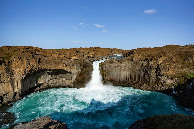
The roar arrives before the view—a deep, resonant thunder that vibrates through the soles of your boots as you step onto the black gravel plain. Here, at the Aldeyjarfoss waterfall, the Skjálfandafljót River plunges 20 meters over a sweeping amphitheater of hexagonal basalt columns, creating a curtain of white water against stark volcanic stone. It is mid-afternoon—around 3:00 PM in July—and the Arctic sun hangs low enough to cast long shadows through the columnar joints, illuminating moss that clings to crevices like green velvet. The air temperature sits at 12°C (54°F), but the mist rising from the impact zone chills the skin to 8°C (46°F), demanding respect and preparation. This isn't merely a scenic overlook; it is a geological masterpiece carved by glacial floods and lava flows over 10,000 years ago, accessible only via a rugged 15-kilometer gravel road that filters out the casual passerby. In 2026, as Iceland manages increasing tourist pressure on fragile highland sites, Aldeyjarfoss waterfall matters more than ever—a sanctuary of raw beauty, a test of responsible access, and a reminder that the earth's most dramatic art requires effort to witness.
Why Aldeyjarfoss Waterfall Embodies Iceland's Volcanic Artistry
The Aldeyjarfoss waterfall—often called the "Waterfall of the Islands"—represents one of the most striking examples of columnar basalt formations in the North Atlantic, rivaling the famous Svartifoss in the south but with significantly greater water volume. Geologically, the site solves a visual puzzle: how cooling lava contracts into perfect hexagonal prisms. These columns, formed during the Tertiary period approximately 2 million years ago, frame the 20-meter (66-foot) drop in a natural arcade that looks architecturally engineered rather than naturally eroded. The river itself, the Skjálfandafljót, stretches 178 kilometers from the interior highlands, carrying glacial melt that maintains a flow rate averaging 100 cubic meters per second during summer months.
Beyond aesthetics, the location fulfills a historical need for isolation and preservation. Unlike waterfalls along the Ring Road, Aldeyjarfoss remained inaccessible to vehicles until Road 842 was upgraded in the early 2000s. Before this, only hikers or horseback riders could reach the site, protecting it from mass tourism for decades. Today, the gravel surface remains unpaved, acting as a natural barrier that limits visitor numbers to approximately 50,000 annually—a fraction of the crowds at Gullfoss. The Icelandic Environment Agency monitors erosion along the cliff edges, installing protective fencing in 2018 to prevent accidents while preserving sightlines.
Culturally, the name references the nearby island of Aldey, though the waterfall itself stands as a monument to the volcanic forces that built Iceland. Walking the trail to the viewing platform, you traverse lava fields composed of tholeiitic basalt, the same material that forms the ocean floor. The site stands as a testament to the convergence of fire and ice—where molten rock met glacial water to create a landscape that continues to evolve with every seasonal flood.
The Best Time to Experience Aldeyjarfoss Waterfall
For safe access and maximum flow, plan your visit between June 20 and August 15, when Road 842 is fully open and daytime temperatures range from 10–15°C (50–59°F). The best lighting occurs between 2:00–5:00 PM, when the sun illuminates the basalt columns directly without casting the canyon into deep shadow. During these months, the river carries peak glacial melt, ensuring the waterfall displays its full power and width across the 30-meter span.
Shoulder season (June 1–19 and August 16–September 10) brings cooler temperatures of 5–10°C (41–50°F) and fewer vehicles, but road conditions become unpredictable due to rain-induced mud. Winter visits (November–March) are strongly discouraged; Road 842 closes officially, temperatures drop to -10°C (14°F), and the waterfall partially freezes, creating hazardous ice formations on the trail. Additionally, daylight shrinks to 4–6 hours, limiting exploration time significantly.
Avoid visiting during heavy rain warnings issued by the Icelandic Meteorological Office, as the gravel road becomes impassable and river levels rise dangerously. The site is open 24 hours with no entrance fee, but parking facilities are unstaffed. Always verify road conditions at road.is and weather forecasts at vedur.is before departure, as the Aldeyjarfoss waterfall access route can flood during rapid thaw events even in summer.
Approximate Budget for a 7-Day Trip (2026)
North Iceland offers moderate pricing compared to the south, though 4WD rental requirements increase transportation costs. These 2026 estimates assume a mid-range travel style, accounting for Iceland's projected 3.7% inflation rate and current exchange rates (1 USD = 0.92 EUR). Prices reflect the Akureyri/Mývatn region, which serves as the base for visiting Aldeyjarfoss.
- Accommodation: €130–€190 per night for guesthouses or farm stays in Akureyri or Reykjahlíð; budget hostels from €70; luxury hotels €260+
- Food: €65–€85 per day—breakfast €15 (often included), lunch €20 (soup and bread at local cafés), dinner €35–€45 (lamb stew or fish at Vogafjós)
- Transportation: Rental car essential: €90–€120/day for 4WD vehicle (gravel protection mandatory); fuel €2.15/liter (approximately €140 for week); Akureyri to Aldeyjarfoss round-trip: 120 km; Route 1 plus Route 842
- Attractions: Aldeyjarfoss free; Mývatn Nature Baths €38; Hverir geothermal area free; Guided highland tour €90
- Miscellaneous: Waterproof hiking boots rental €30; thermal gear €40; travel insurance €50; parking fees €0
Total estimated cost for 7 days: €1,600–€2,000 per person (excluding international flights)
7 Essential Aldeyjarfoss Waterfall Experiences
- Hike the main viewing trail: This marked path (65°43.800'N, 17°15.200'W) leads from the parking lot to the primary overlook in 10 minutes. The descent is steep and rocky; wear sturdy boots with ankle support. Best photographed mid-afternoon when sunlight hits the basalt columns. The mist is heavy here—protect your camera lens.
- Explore the riverbank below: A rugged scramble down the slope leads to the base of the falls. Allow 30 minutes each way. The noise is deafening at close range, vibrating through your chest. The rocks are extremely slippery; do not approach the water's edge. Best visited early morning when no other hikers are present.
- Photograph the basalt columns: Focus on the geometric patterns framing the water. Use a polarizing filter to cut through mist glare. The columns are hexagonal and perfectly aligned—a rare geological occurrence. Zoom in on moss growing between stones for texture contrast. Best light occurs between 3:00–5:00 PM.
- Walk the upstream lava field: Follow the riverbank 500 meters upstream for a view of the waterfall from above. The terrain is uneven lava rock; watch your step. This perspective reveals the width of the Skjálfandafljót before the drop. Best visited late evening when wind is calm.
- Listen to the acoustic resonance: Stand quietly at the viewing platform and close your eyes. The Aldeyjarfoss waterfall creates a low-frequency hum caused by water hitting the pool below. This sound carries over 1 kilometer in still air. Best experienced without wind noise interfering.
- Watch for Arctic terns: The cliffs above the falls host nesting birds from May to August. They dive aggressively to protect nests; keep your head covered. Bring binoculars to observe without disturbing. The contrast of white birds against black rock is striking. Best viewed with telephoto lens.
- Experience the midnight sun glow: On June 21, the sun sets around 12:15 AM. Return to the falls around 11:00 PM to see the basalt glow amber in perpetual twilight. Temperatures drop rapidly; wear thermal layers. The site is empty at this hour, offering profound solitude.
3 Hidden Gems Most Travelers Miss
- Sigöldufoss waterfall: Located 15 kilometers south along Route 842, this smaller cascade features similar basalt columns but receives 90% fewer visitors. Access via unmarked pull-off 2 kilometers past Aldeyjarfoss turnoff. The hike takes 20 minutes round-trip. No facilities here—bring water. Best visited midday when shadows reveal column depth. Often completely empty.
- Old Road 842 Remnants: Near the parking area, remnants of the original track before 2000 upgrades remain visible. These ruts show how difficult access used to be. Look for the old stone cairns marking the path. Access is unrestricted during daylight hours. This spot offers tangible history of Iceland's infrastructure development. Best visited late afternoon when shadows highlight the ruts.
- Hrafnabjargarfoss viewpoint: Drive 10 kilometers north to this lesser-known waterfall on the same river system. It lacks the columns but offers raw power in a narrow canyon. Access via gravel track off Route 842. Open daylight hours; no entry fee. Most tour buses skip this for Aldeyjarfoss. The site offers context for the river's full journey. Contact: visitnorthiceland.is for track conditions.
Cultural & Practical Tips
- Respect the terrain: The basalt rock is razor-sharp when dry and slippery when wet. Do not climb the columns; they are fragile and protected. Fines for damaging geological formations can reach €500. Respect barriers—they prevent fatal falls on unstable edges.
- Vehicle requirements: Route 842 is an F-road (gravel/highland). A 4WD vehicle is mandatory; 2WD cars risk damage and void insurance. Check road.is for opening status. River crossings are not required but mud can be deep. Drive slowly to minimize dust for other travelers.
- Weather preparedness: North Iceland weather changes rapidly. Even in July, pack: windproof waterproof jacket, thermal base layers, sturdy hiking boots, hat and gloves. Check vedur.is for real-time forecasts. Wind speeds can exceed 20 m/s (45 mph), making standing near the falls difficult.
- Photography etiquette: Tripods permitted but don't block pathways for other visitors. Drone use requires special permit from Umhverfisstofnun (Icelandic Environment Agency)—apply at ust.is at least 14 days in advance. The mist can damage equipment; use protective filters.
- Local phrases: Learn these Icelandic essentials: Takk (tahk) = Thank you; Góðan daginn (go-than die-in) = Good day; Fallegur foss (fal-leg-ur foss) = Beautiful waterfall. Effort with language earns warm smiles from locals.
- Emergency contacts: Dial 112 for all emergencies. Nearest hospital: Akureyri Hospital, 90 km south (+354 470-1000). Cell coverage is spotty at the falls; download offline maps via Google Maps before arrival.
- Accessibility note: The main viewing platform is accessible for most mobility levels but involves gravel paths. The riverbank scramble is not accessible. Contact visitnorthiceland.is for detailed accessibility maps before traveling.
Conclusion: Travel with Reverence, Not Just Checklists
Aldeyjarfoss demands more than a quick photo stop and a hashtag—it asks for your caution, your patience, your willingness to stand respectfully on ground that is actively shaped by water and stone. As you walk these trails in 2026, remember that each footprint lands on terrain sacred to both geological history and natural preservation. The basalt columns aren't merely scenic backdrops; they are ancient records of volcanic fire, written in hexagonal stone.
Responsible travel here means staying on paths, respecting road closures, and leaving only footprints on the gravel. It means understanding that the isolation of this site is a feature, not a bug—protecting the landscape from the wear of mass tourism. When you hire local guides, drive appropriate vehicles, and follow safety barriers, you participate in an economy that values preservation over exploitation.
So linger past the guidebook's recommended 30 minutes. Sit on a safe rock and watch the water carve the stone. Let the thunder of the falls remind you that some places aren't meant to be conquered or consumed—they're meant to be witnessed with humility, protected with intention, and carried in memory long after your tires have left the gravel road.