
Atlantic Ocean Road Engineering Marvel Meets Norwegian Coastal Wilderness
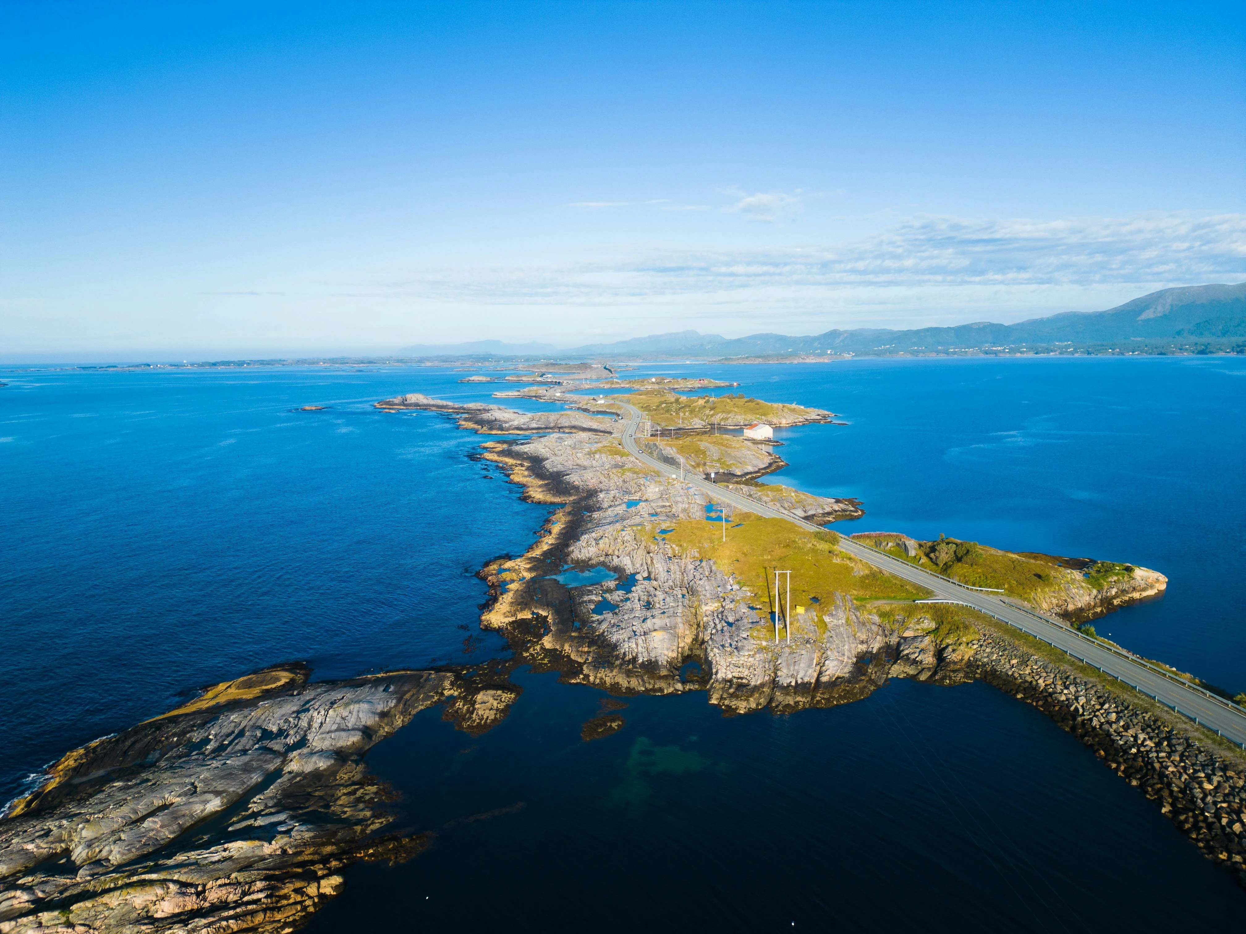
The wind whips across the asphalt, carrying the sharp tang of salt spray as you drive the Atlantic Ocean Road—a ribbon of concrete and steel that dances across the churning Norwegian Sea. Waves crash against the bridge pillars below, sending white foam spiraling into the air, while seagulls circle the dramatic arch of the Storseisundet Bridge, the route's crown jewel. This 8.3-kilometer (5.2-mile) stretch of County Road 64, opened in 1989, connects the islands of Averøy to the mainland near Kristiansund, weaving through a seascape where the North Atlantic unleashes its full fury. You grip the steering wheel as the road dips and rises, creating an illusion of plunging into the ocean before climbing toward the sky. The light is diffused through low-hanging clouds, casting an ethereal glow on the gray water that stretches to the horizon. In 2026, as virtual experiences replace physical journeys, the Atlantic Ocean Road matters because it remains a visceral testament to human ingenuity against nature's power—a place where you feel every gust of wind and hear every crash of wave, reminding us that some roads are not just traveled but experienced with all five senses.
Why Atlantic Ocean Road Embodies Norwegian Coastal Engineering
The Atlantic Ocean Road is not merely a transportation route; it is a masterpiece of civil engineering that solved a critical connectivity problem for the remote communities of Møre og Romsdal county. Before its construction, island residents depended on ferries that operated only in calm weather, isolating them during winter storms. The road, which cost 122 million NOK (approximately €12 million in 1989 currency), connects eight bridges across four small islands: Vevang, Geitøya, Lille Lauvøya, and Storlauvøya. The Storseisundet Bridge, the longest at 260 meters (853 feet), features a dramatic parabolic arch that rises 23 meters (75 feet) above sea level, creating the iconic "road to nowhere" optical illusion that has made this route world-famous.
The engineering challenges were immense. Builders had to contend with winds exceeding 100 km/h (62 mph), waves reaching 15 meters (49 feet) during storms, and a seabed composed of loose sediment. The solution involved constructing concrete caissons—hollow chambers sunk into the seabed—that serve as foundations for the bridge pillars. These structures are reinforced with steel and designed to withstand the corrosive effects of salt water for over 100 years. The road surface itself is elevated 5–10 meters above the water, with drainage systems that prevent flooding during high tides. In 2026, the Atlantic Ocean Road fulfills multiple needs: it remains a vital transportation link for 1,500 daily commuters, serves as a tourist attraction drawing 300,000 visitors annually, and stands as a symbol of Norway's commitment to connecting even its most remote communities. The route was designated a National Tourist Route in 2012, recognizing its cultural and aesthetic significance.
The Best Time to Experience Atlantic Ocean Road
For dramatic storm-watching and optimal photography, target October 15–December 15. During this window, temperatures range from 4–9°C (39–48°F), and the North Atlantic generates its most spectacular waves, often reaching 10–15 meters (33–49 feet) in height. The light is moody and atmospheric, perfect for capturing the road's dramatic character. For pleasant driving conditions and midnight sun photography, visit June 15–July 20. Temperatures range from 12–18°C (54–64°F), and daylight extends to 20 hours, allowing for extended exploration. The best light for photography occurs between 10:00 PM–12:00 AM during the midnight sun period.
Avoid January 15–March 1 if you dislike extreme weather: this period brings the harshest winter storms, with winds exceeding 120 km/h (75 mph) that can close the road for safety. Also avoid visiting during heavy fog, common in May, when visibility drops below 50 meters. For real-time road status and weather warnings, check www.vegvesen.no or call +47 02600. Weather forecasts are available via Yr.no. Note that the road remains open 24 hours year-round, but parking areas may close during severe storms.
Approximate Budget for a 7-Day Trip (2026)
The Atlantic Ocean Road region involves moderate costs typical of Western Norway's coastal areas. This budget assumes mid-range travel with 3-4% inflation adjustment from 2024 baselines. Prices are estimated in Euros (€); local currency is Norwegian Krone (NOK). Costs reflect Kristiansund, Averøy, and Molde areas.
- Accommodation: €160–€250 per night for a double room in a 3-star hotel in Kristiansund or Molde. Budget hostels (Kristiansund Vandrerhjem): €55–€75 per bed. Upscale options (Thon Hotel Kristiansund): €280–€420 per night.
- Food: €75–€110 per day per person
- Breakfast: €16–€22 (hotel buffet with bread, cheese, jam)
- Lunch: €22–€35 (café sandwich €28, fish soup €32, or grocery picnic €20)
- Dinner: €38–€60 (restaurant main: cod €42, lamb €45, pasta €32; add €14 for beer)
- Transportation:
- Car rental (7 days, essential for this route): €600–€800 including fuel
- Train (Oslo–Molde): €80 one-way, €150 round-trip
- Local bus day pass: €12
- Ferry (if exploring islands): €25–€40
- Attractions:
- Atlantic Ocean Road: Free (no toll)
- Atlantic Ocean Road Visitor Center: €8
- Kristiansund Museum: €14
- Molde Panorama viewpoint: Free
- Guided road tour: €45
- Miscellaneous:
- Souvenirs: Road poster €15, wool sweater €100, local fish products €25
- Coffee and pastry: €10
- Travel insurance (7 days): €45–€65
- eSIM data plan: €20–€30
Total for 7 days (mid-range, per person, double occupancy): €2,000–€2,500
Budget travelers can reduce costs to €1,300–€1,600 by staying in hostels, cooking meals, and using public transport where possible. Luxury seekers should budget €4,500+ for boutique hotels and fine dining.
6 Essential Atlantic Ocean Road Experiences
- Drive the Storseisundet Bridge: This is the iconic moment. Approach from the Vevang side heading east. The bridge appears to end abruptly, creating a thrilling optical illusion. Drive slowly (speed limit 60 km/h) to appreciate the engineering. Stop at the viewing platform on the eastern side. The wind is strongest here; hold onto hats. Spend 15 minutes photographing from different angles. Visit at sunset when the light is golden. It is the most photographed section; arrive early to avoid crowds. Respect the no-parking zones on the bridge itself.
- Visit the Visitor Center: Located at Geitøya, midway along the route. Open daily 9:00 AM–6:00 PM in summer. The center features exhibits on the road's construction and local marine life. View the interactive displays showing storm simulations. Entry costs €8; free for under 16. The café serves fresh seafood. Allow 60 minutes for a full visit. It provides essential context for the engineering achievement. Free parking available.
- Storm Watching: Visit during autumn or winter storms for a dramatic experience. Park at designated safe areas (never on the road). Watch waves crash over the bridges, sometimes reaching 15 meters high. The sound is thunderous. Bring waterproof clothing; spray reaches the viewing platforms. This is not for the faint-hearted. Check weather forecasts carefully. Never approach the water's edge. It is a raw display of nature's power.
- Fish at the Rest Areas: Several parking areas along the route have fishing platforms. Bring your own gear. Cod and mackerel are common catches. No fishing license required for saltwater fishing. The best spots are at Lille Lauvøya and Storlauvøya. Visit at dawn or dusk for best results. Clean your catch at designated stations. It combines the drive with local tradition. Free access to all platforms.
- Photograph the Bridges: The route offers eight distinct bridges, each with unique architecture. Use a wide-angle lens to capture the curves. The best light is during golden hour (8:00–10:00 PM in summer). Include the ocean for scale. Tripods are essential for long exposures of waves. Respect traffic; never stand on the road. The Geitøya bridge offers the best sunset views. Allow 2–3 hours for a photography session.
- Walk the Coastal Paths: Several hiking trails branch from the road. The Vevang peninsula offers a 3-kilometer coastal walk with ocean views. The path takes 90 minutes round-trip. It is marked with red T-paint. The terrain is rocky; wear sturdy boots. You will see seabirds nesting on cliffs. It provides a different perspective of the route. Free access; no permits required.
3 Hidden Gems Most Travelers Miss
- Eldhusøya Rest Area: Located at the western end near Vevang. This small island features a protected harbor and traditional fishing cabins. Most drivers rush past without stopping. Park at the designated area and walk the 500-meter path to the old boathouses. They date to the 1800s and are now used by local fishermen. The atmosphere is peaceful and authentic. Best visited at low tide when you can explore the tidal pools. Free access; open 24/7. It offers a glimpse into traditional coastal life.
- Underwater Viewing Platform: At the Geitøya visitor center, a glass floor section allows you to view marine life below. Most tourists focus on the bridges above. The platform is located inside the visitor center building. You can see crabs, fish, and seaweed in the shallow water. Best visited during high tide when water is clearest. It is overlooked because it is indoors. No extra cost beyond visitor center entry. A unique perspective on the ecosystem.
- Midnight Sun Reflection Point: Located 2 kilometers east of Storseisundet Bridge. A small pull-off area (coordinates 63.0833°N, 7.3167°E) offers perfect reflections of the road in tidal pools during calm evenings. Most photographers miss this spot. Visit between 11:00 PM–1:00 AM in June–July. The road reflects in the shallow water, creating a mirror effect. Best on windless nights. No facilities exist; bring your own refreshments. It is a photographer's secret for surreal images.
Cultural & Practical Tips
- Driving Safety: The speed limit is strictly enforced at 60 km/h (37 mph). Police conduct regular checks. The road is narrow with no shoulders in places. Pull over at designated areas only. Never stop on the bridges. Wind can be severe; hold the steering wheel firmly. In winter, ice is common; use winter tires (mandatory November–March). Your safety is your responsibility. The road can close during extreme weather; check status before traveling.
- Weather Preparedness: Weather changes rapidly on the coast. Pack waterproof jacket and layers even in summer. Temperatures can drop 5–8°C near the water. Wind chill makes it feel colder. Umbrellas are useless in strong winds. Dress in wool; it stays warm when wet. Check Yr.no hourly forecasts. The visitor center provides shelter during storms. Bring sunglasses; glare off water is intense.
- Useful Phrases:
- "Takk" (tahk) = Thank you
- "Unnskyld" (oon-shool) = Excuse me
- "Hvor er toalettet?" (voor ehr toa-let-et) = Where is the toilet?
- "Snakker du engelsk?" (snak-ker doh eng-elsk) = Do you speak English?
- Photography Guidelines: Photography is allowed throughout. Tripods are permitted in parking areas but not on the road. Respect traffic; never block lanes for photos. Drones are allowed but require registration with Luftfartstilsynet. Do not fly over moving vehicles. The best light is golden hour. Use a polarizing filter to reduce water glare. Ask before photographing individuals. Share photos responsibly; tag #atlanterhavsveien.
- Facilities: Restrooms are available at the visitor center and Eldhusøya. They are free to use. No gas stations exist on the route; fill up in Kristiansund or Molde. Mobile coverage is good throughout. Emergency phones are located at each bridge. The nearest hospital is in Molde (40 km). Carry water and snacks; services are limited.
- Accessibility: The visitor center is fully wheelchair accessible with ramps and elevators. Viewing platforms have accessible paths. The road itself is not walkable due to traffic. Wheelchair users can enjoy the rest areas. Accessible parking is available at all stops. Assistive listening devices are available for tours. Book assistance in advance via +47 71 58 58 00.
- Environmental Respect: Do not litter; use designated bins. The ocean is pristine; keep it that way. Do not disturb seabirds nesting on cliffs. Stay on marked paths to protect vegetation. Fishing is allowed but follow size limits. Do not feed wildlife. Respect private property on the islands. This ensures preservation for future generations.
Conclusion: Travel with Reverence, Not Just Checklists
The Atlantic Ocean Road is not a scenic detour; it is a confrontation with the raw power of the North Atlantic. In 2026, as tourism becomes increasingly curated, this route demands respect for nature's unpredictability. Travel here not to tick a box but to witness the marriage of human engineering and oceanic fury. Feel the wind; hear the waves; understand that this road exists at the mercy of the sea. Leave only tire tracks; take only the humility that comes from standing between sky and ocean. When you depart, carry the memory of those waves crashing against concrete pillars. For in the end, the true value of this journey is not the photo you post, but the realization that we build our roads not to conquer nature, but to coexist with it—a fragile balance of steel and salt, courage and respect, that defines the Norwegian relationship with the sea.