
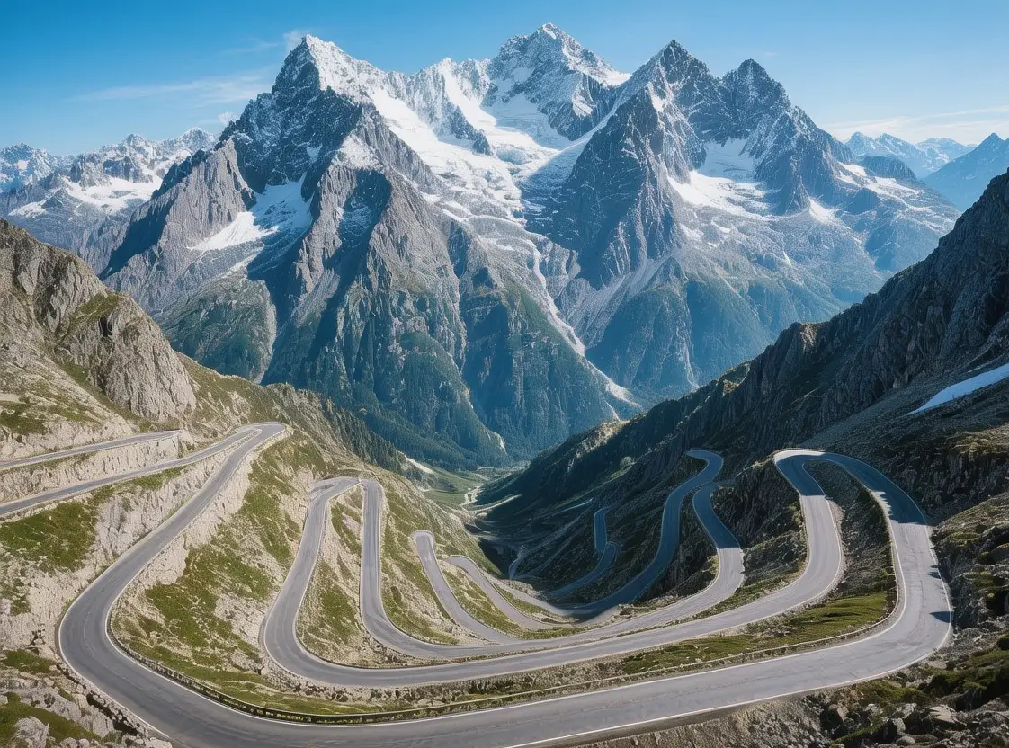
Furka Pass Historic Hairpins Meet Alpine Clouds
The wind howls across the summit—a sharp, thin sound that cuts through the silence of the high Alps as you stand at 2,429 meters (7,969 feet) above sea level. You grip the steering wheel of your car, feeling the engine strain slightly against the gradient as you navigate the 25-kilometer stretch of asphalt that connects the canton of Valais with Uri. The air here is crisp and thin, scented with wild alpine flowers and the faint exhaust of the occasional vintage car climbing the 25 hairpin turns from Gletsch. To the west, the Rhone Glacier glimmers like a frozen river; to the east, the landscape drops steeply into the Urseren Valley. This pass has served as a critical transit route since the road was completed in 1866, linking the German-speaking north with the French-speaking south of Switzerland. In 2026, as modern tunnels bypass the summit in minutes, the Furka Pass remains a sanctuary of slowness—a place where the physical effort of ascent rewards you with a perspective that speed cannot replicate, reminding you that some journeys are meant to be felt rather than merely completed.
Why Furka Pass Embodies Alpine Connectivity
The Furka Pass represents a unique fusion of geological challenge and human engineering, solving the historical problem of traversing the main Alpine ridge that divides the Rhone and Reuss valleys. First opened as a paved road in 1866, the pass utilizes local granite and gneiss for its retaining walls, materials chosen for durability against the harsh winter freezes and heavy snow loads that exceed 10 meters annually. The summit sits at 2,429 meters, making it one of the highest paved passes in the Swiss Alps, a height that requires careful acclimatization for some visitors though the gradual ascent by road mitigates altitude effects. The engineering feat involved carving the route through vertical rock faces using black powder explosives in the 1860s, allowing the road to bypass previously impassable cliffs and link the valley floors.
Beyond engineering, the pass fulfills a cultural need for connection in a fragmented continent. The opening of the Furka Base Tunnel in 1982 reduced transit time for commercial traffic but shifted the focus from experience to efficiency. The historic pass road, now protected as a heritage site, preserves the original 25-kilometer route between Gletsch and Realp. Today, the infrastructure balances preservation with access: the Historic Alpine Passes foundation maintains the surface, while the Swiss Federal Roads Office ensures safety without modernizing the character. This living heritage proves that historic transit routes can remain functional for tourism and cycling while maintaining the raw authenticity of their 19th-century construction.
The Best Time to Experience Furka Pass
For optimal conditions combining open road access, clear visibility, and comfortable hiking weather, visit between July 1–September 30. During these windows, daytime temperatures at the summit range from 10–18°C (50–64°F), while Gletsch at the base enjoys 15–25°C (59–77°F). The ideal time to drive or cycle the pass is 9:00–11:00 AM, when the morning light illuminates the valley without the glare of midday sun and traffic is lightest.
Winter visits (October–June) are impossible for the pass road, as it closes completely due to snow depths exceeding 10 meters. The base tunnel remains open year-round, but the summit experience is inaccessible. Summer peak season (July 20–August 15) brings temperatures up to 20°C (68°F) at the top but also increased motorcycle and vintage car traffic. The afternoon breeze provides relief, but thunderstorms can develop rapidly after 2:00 PM.
Avoid these periods: October 1–June 30 (road closure due to snow), December 23–January 5 (holiday traffic congestion in tunnels), and late September (early snowstorms may limit access). For real-time road status and weather warnings, verify conditions at tcs.ch or check the Swiss Federal Roads Office at astra.admin.ch for seasonal opening dates.
Approximate Budget for a 7-Day Trip (2026)
This budget estimate reflects mid-range travel preferences for a solo traveler or couple, based on 2026 pricing adjusted for Switzerland's 2.5% annual inflation rate (Swiss Federal Statistical Office data). The Furka region is expensive, but strategic planning with the Swiss Travel Pass offers significant value for extensive exploration including the pass and surrounding valleys.
Accommodation:
• Budget hostel (dorm bed): CHF 65–CHF 90 per night (Youth Hostel Andermatt, 30-minute drive from pass)
• Mid-range hotel (3-star, valley center): CHF 220–CHF 320 per night (Hotel Belvédère or Glacier Hotel)
• Upscale boutique (4-star, mountain view): CHF 450–CHF 650 per night (The Chedi or Radisson Blu)
Food: CHF 85–CHF 125 per day
• Breakfast: CHF 22–CHF 32 (hotel buffet with Swiss muesli and local bread)
• Lunch: CHF 32–CHF 48 (mountain hut Rösti or valley café sandwich)
• Dinner: CHF 55–CHF 80 (traditional fondue or Ticino risotto)
• Coffee/pastry: CHF 9–CHF 15
Transportation:
• Swiss Travel Pass (8 days, 2nd class): CHF 432 (covers trains, buses, boats, museums)
• Vignette (Highway Toll): CHF 45 (required for road tunnels)
• Airport transfer (Zürich to Andermatt): covered by Swiss Travel Pass or CHF 55 train
• Local bus (Line 1, 2): CHF 4.20 per ride (free with Swiss Travel Pass)
Attractions:
• Furka Pass Road: Free
• Rhone Glacier Ice Grotto: CHF 15
• Steam Train Ride: CHF 40 (50% off with Swiss Travel Pass)
• Glacier Express Train: CHF 150 (50% off with Swiss Travel Pass)
• Guided Pass Walking Tour: CHF 45
Miscellaneous:
• Souvenirs (Cheese, wine, cowbell): CHF 70–CHF 200
• Travel insurance (7 days): CHF 55–CHF 85
• SIM card/data (Swisscom 10GB): CHF 45
• Emergency fund: CHF 200
Total estimated cost (mid-range): CHF 2,800–CHF 3,600 for 7 days
Budget traveler option: CHF 1,500–CHF 1,800
Luxury experience: CHF 6,500–CHF 11,000+
7 Essential Furka Pass Experiences
1. Historic Road Drive: Drive the 25-kilometer pass road from Gletsch to Realp at 9:00 AM. The 25 hairpin turns offer changing perspectives. Stop at the summit for photos. Free access. Best visited: Morning for light. Allow 2 hours.
2. Rhone Glacier Visit: Walk to the glacier tongue at 10:30 AM. The ice has retreated significantly but remains impressive. The path is marked and safe. Free access. Allow 60 minutes. Wear sturdy shoes.
3. Ice Grotto Tour: Enter the man-made ice cave at 11:30 AM. The tunnels are carved into the glacier annually. The temperature is -2°C inside. Open June–September 9:00 AM–5:00 PM. Cost: CHF 15. Allow 45 minutes.
4. Hotel Belvédère Stop: Visit the abandoned grand hotel at 1:00 PM. The building dates to 1882 and is a photographic landmark. The structure is unsafe to enter but exterior viewing is allowed. Free access. Best photographed: Afternoon.
5. Steam Train Ride: Board the Dampfbahn Furka-Bergstrecke at 2:00 PM. The historic steam train runs on the old mountain route. The journey takes 1 hour. Cost: CHF 40. Book in advance. Best visited: Summer months.
6. Summit Monument: Stand at the summit cross at 2,429 meters at 3:00 PM. The panorama covers 360 degrees of Alpine peaks. Free access. Allow 30 minutes. The wind is strong; bring a jacket.
7. Mountain Hut Dining: Eat at the Bergrestaurant Furka at 6:00 PM. Order the Käseschnitzel or local cheese platter. The rustic interior dates to 1900. Prices: CHF 35–CHF 55. Reservations recommended. Best visited: Sunset.
3 Hidden Gems Most Travelers Miss
• Old Hospice Ruins: Located near the summit, these 19th-century ruins housed travelers before the hotel was built. Most visitors only see the new restaurant. Access: 10-minute walk from the parking lot. Open daily dawn to dusk. Free entry. Insider tip: The stone walls offer wind shelter for a quiet moment.
• Muttbach-Belvédère Station: A ghost railway station on the old Furka line. The platform is overgrown but the view is unique. Access: Hike from the pass road (30 minutes). Open daily. Free entry. Best visited: Morning light. The history is palpable.
• Galenstock Viewpoint: A specific rocky outcrop 1 kilometer west of the summit offering the best view of the Galenstock peak. Most tourists stop at the main parking. Access: Follow yellow hiking signs. Open daily dawn to dusk. Free entry. Insider tip: Bring water; no facilities here. The trail is steep but marked.
Cultural & Practical Tips
• Driving regulations: The pass road is narrow. Yield to uphill traffic. Speed limit: 30–50 km/h. Motorcycles are common; give them space. The Vignette (CHF 45) is required for tunnels but not the historic pass road.
• Language basics: The region speaks German (north) and French (south). Learn these phrases: "Grüezi" (GRÜE-tsi) for hello, "Bonjour" (bon-ZHOOR) for hello, "Danke/Merci" for thank you. English is widely spoken.
• Weather considerations: Summit weather changes rapidly. Even in summer, temperatures can drop to 5°C (41°F). Carry a windproof jacket. Afternoon thunderstorms are common; descend before 3:00 PM if hiking.
• Photography guidelines: Tripods are permitted on public paths but not on the road (safety hazard). Drone usage requires FOCA authorization. Respect privacy; do not photograph vehicles without consent.
• Altitude awareness: At 2,429 meters, some visitors experience mild altitude sensitivity. Ascend slowly, stay hydrated. The road ascent is gradual; if you feel dizzy, stop at the hospice until acclimatized.
• Cycling safety: The pass is popular with cyclists. Wear bright clothing. Descend cautiously; the asphalt is slippery when wet. Lights are mandatory in tunnels.
Conclusion: Travel with Reverence, Not Just Checklists
The Furka Pass stands not merely as a road, but as a stone chronicle of European connection—a rhythm that persisted through empires, wars, and the industrial age. As you drive the hairpin turns in 2026, listening to the wind mingle with the distant hum of the tunnel below, remember that this route survives because travelers respect its history. Responsible travel means staying on the marked paths, supporting the local mountain economy, and understanding that the silence of the summit is a fragile resource worth protecting. Slow down. Touch the granite. Watch the clouds roll over the ridge. Leave no trace on the historic stones. This pass will endure long after your visit ends, carrying the stories of future generations who seek connection with the Alps. Carry forward not just photographs, but a deeper appreciation for the balance between sharing our world's wonders and preserving them for those who will walk these stones in 2126.