
Stegastein Viewpoint Cantilevered Steel Meets Fjord Silence
At 5:30 AM, the air above the Stegastein viewpoint hangs crisp at 650 meters (2,133 feet) elevation, carrying the scent of damp granite and wild juniper from the steep slopes cascading 450 meters below. You hear it before the sun crests the mountain ridges—the distant hum of wind vibrating against the steel girders, a rhythmic pulse that has defined this pass since architects first anchored the platform to living rock in 2006. This is not merely a lookout; it is an architectural marvel spanning 30 meters in length between Aurland and the high plateaus, guarding the legacy of Norwegian National Tourist Routes with a design that defies gravity. The light here possesses a specific quality—filtered through morning mist, creating dramatic shadows that shift with the sun's arc over the Aurlandsfjord. In 2026, as natural landscapes face overtourism, the Stegastein viewpoint matters more than ever: it represents a rare convergence of human ingenuity and pristine wilderness, where the engineering isn't intrusive but harmonious, demanding you slow down to match the mountain's ancient pace.
Why Stegastein Viewpoint Embodies Norwegian Design Heritage
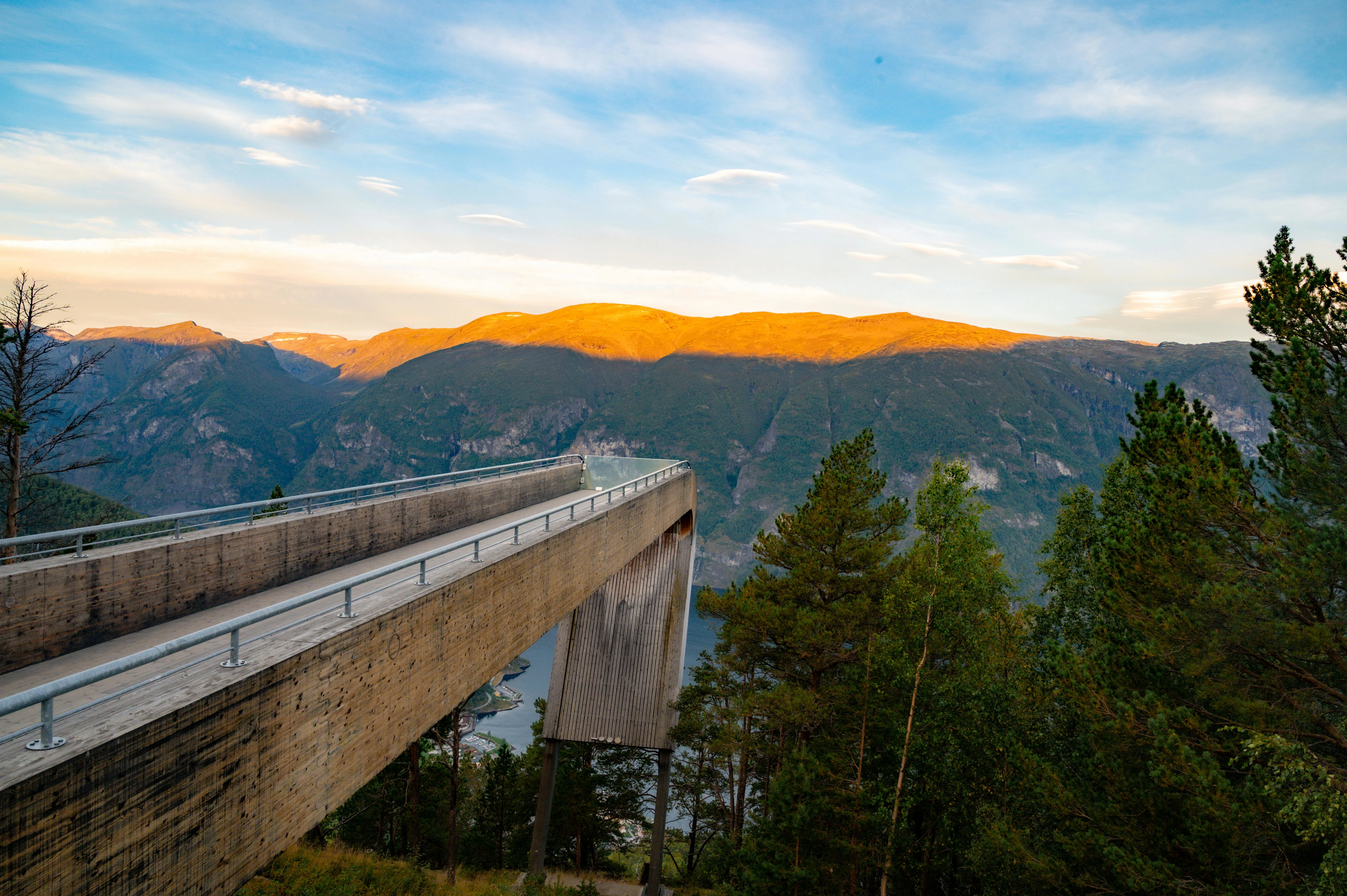
The Stegastein viewpoint solves a fundamental architectural problem: how to frame a vast landscape without obstructing it. When the design competition concluded in 2006, architects Todd Saunders and Tommie Wilhelmsen addressed a critical need for accessible beauty along the Aurlandsfjellet road. Today, the infrastructure has evolved into a model of sustainable tourism. The platform, officially opened on June 21, 2012, sits cantilevered 450 meters above the water, ensuring tourism supports conservation efforts. This engineering addresses a deeper need: the demand for immersion in an untouched wilderness. The structure's length isn't arbitrary; it measures precisely 30 meters, constructed from laminated wood and steel weathering patina that blends with the rock face.
Historically, the region fulfilled a need for mountain transit routes. The old road, completed in 1938, employed 1,000 workers over 15 years, standing as markers of 20th-century resilience. This preservation creates a unique cultural fabric. The name "Stegastein" translates to "stepping stone," reflecting the path's role as a bridge between valleys. The National Tourist Route project, initiated in 1998, transformed the road into one of Norway's eighteen scenic routes, bringing 400,000 visitors annually. The infrastructure addresses a craving for connection: the viewing deck spans 120 square meters, marked with informational panels installed in 2015. With 650 meters of elevation and 30 meters of dramatic overhang, the facility operates like an open-air museum. This isn't just recreation; it's a testament to Norwegian stewardship, where access is granted only to those who respect the fragile balance between design achievement and ecological integrity. The geological surveys, dating to 1930, remain active, proving heritage can be scientific.
The Best Time to Experience Stegastein Viewpoint
For optimal visibility and access: May 15–October 15 offers the warmest air temperatures and clearest visibility. Daytime air temperatures range from 10–18°C (50–64.4°F) at the summit; nights drop to 3–8°C (37.4–46.4°F). Snow melt peaks during late June. For photography: June 1–August 31 provides the longest daylight hours. Sunrise occurs at 4:00 AM; arrive by 5:00–6:30 AM for soft light on the fjord without tour bus congestion.
Avoid July 15–August 5 (peak cruise ship season)—the parking areas reach 100% capacity by 10:00 AM, and wait times exceed 60 minutes. Also avoid November 1–April 30 if you seek full access; the mountain road often closes due to snow and avalanche risk, though winter access is sometimes possible with convoys. Winter sports are limited here; this is a cultural destination, not a ski resort.
For specific experiences: arrive at the Aurland starting point by 7:00–8:00 AM to beat the tour bus influx. The viewpoint is least crowded on weekdays (Tuesday–Thursday). Check live road status at vegvesen.no or call the road information line at +47 175. Note that the platform closes during high winds; summer hours are daily.
Approximate Budget for a 7-Day Trip (2026)
Pricing methodology: Costs reflect mid-range travel (3-4 star hotels, mix of self-catering and restaurant dining, public transportation) during peak summer season (July 2026). All prices include Norway's 25% VAT. Prices adjusted for 4% inflation projected for 2026. Currency is Norwegian Krone (NOK).
Accommodation: NOK 2,300–NOK 4,100 per night for double room in 3-star hotel in Aurland/Flåm; NOK 1,700–NOK 2,900 in guesthouses in nearby Lærdal. Budget hostels: NOK 750–NOK 1,150 per person.
Food: NOK 750–NOK 1,400 per day per person
- Breakfast: NOK 190–NOK 340 (hotel buffet with muesli, cheese, bread)
- Lunch: NOK 240–NOK 420 (roadside café sandwich NOK 170, restaurant salad NOK 310)
- Dinner: NOK 380–NOK 680 (restaurant: salmon dish NOK 440, lamb stew NOK 490)
Transportation:
- Train Oslo to Flåm: NOK 950 one-way (6 hours, scenic route)
- Norway in a Nutshell Pass (5 days): NOK 3,200 for unlimited trains/buses/ferries
- Local bus within region: NOK 50 per ride
- Car rental (7 days): NOK 4,500 including insurance
Attractions:
- Stegastein Access: Free (toll-free national road)
- Nærøyfjord Cruise: NOK 420 adults, NOK 210 children
- Guided Hiking Tour: NOK 900 per person
- Viking Valley Entry: NOK 190
Miscellaneous:
- Souvenir: Troll figurine NOK 290, local wool sweater NOK 1,150
- Travel insurance (7 days): NOK 750–NOK 1,450
- Hiking poles rental: NOK 190
- Lockers at visitor center: NOK 90 per day
Total for 7 days (mid-range): NOK 24,000–NOK 39,000 per person (excluding international flights)
7 Essential Stegastein Viewpoint Experiences
- Drive the Aurlandsfjellet Road: Navigate the scenic route at 8:00 AM. This 45-kilometer section gains 650 meters elevation through switchbacks. The route includes eleven distinct viewpoints. Sit in the driver's seat for best control on the narrow sections. The road operates daylight hours; no toll required. Stop at each hairpin to rest. The engineering is historic; photography through windows is permitted but watch for reflections.
- Walk the Cantilever Platform: Explore the 30-meter overhang at 9:00 AM. This architectural marvel extends over the valley. The route includes three distinct sections. Sit on the benches for best views of the Aurlandsfjord. The structure operates 24 hours; access is free. Stop at the information panels to learn. The design is award-winning; photography through railings is permitted but watch for reflections.
- Dine at the Roadside Café: Located near the summit, this modern venue opens 9:00 AM. Reserve a table for 12:30 PM. Order the "Mountain Platter" (NOK 520): smoked salmon, brunost cheese, flatbread. The interior features floor-to-ceiling windows from the 2012 renovation. Live folk music plays Saturday evenings. The wine list focuses on European varieties (NOK 750 per bottle). Dress code is smart casual; hiking boots are frowned upon—use locker rooms to change.
- Hike the Rallarvegen: Walk the 5-kilometer path to the old construction road. Start at 10:00 AM when birds are most active. The path is packed gravel, suitable for sneakers. Informational panels appear every 500 meters. Stop at the viewpoint platform near the pass for panoramic shots. The trail is marked with red T's; do not deviate into private pastures. Dogs are permitted on leash. Allow 3 hours for the full loop.
- Visit the Flåm Railway: Located in the valley, this historic train opens 9:00 AM–5:00 PM. Entry is NOK 720. Exhibits explain the rail history. Guides offer talks at 11:00 AM and 3:00 PM (Norwegian/English). The center has interactive displays for children. Restrooms are located here—clean and free. Combine with a visit to the adjacent playground for families. The archive contains first editions from 1940.
- Cycle the Descent: Ride the gentle downhill at 2:00 PM. This 20-kilometer journey traverses from summit to valley. The route includes views of the Hallingskarvet. Sit on the bicycle for best immersion in nature. The tour operates daily; bike rental costs NOK 500. Stop at the waterfalls to rest. The path is gravel; photography through action cameras is permitted but watch for reflections.
- Watch the Sunset from the Deck: Take the path at 8:00 PM. The viewpoint terrace at 650 meters offers unobstructed 360° panoramas. On clear days, you see the mountains 30 kilometers away. Bring a warm jacket—even in summer, temperature drops to 6°C (42.8°F) after sunset. The café closes at 9:00 PM for coffee (NOK 75). Stay for 45 minutes to see the light shift on the peaks. Photography tripods allowed but cannot obstruct traffic.
3 Hidden Gems Most Travelers Miss
- The Vatnahalsen Hotel: While crowds flock to the viewpoint, this mountain hotel 5 kilometers east remains quieter. Access via the road from Aurland (10 minutes). The 1-kilometer walking loop requires no guide. The structure dates to 1920 and seats 100 people. Look for the medieval artifacts—still intact. The path is less maintained, offering a wilder feel. Best visited Wednesday mornings when tour groups are absent. Entry by donation only. The acoustics here are rarer than the main viewpoint.
- The Aurland Valley: While tourists drive the pass, this neighboring valley 5 kilometers west remains quieter. Access via PostBus line 851 from Aurland (20 minutes). The 3-kilometer walking loop requires no guide. The path follows historic agricultural terraces from 1800s. Look for the cherry orchards—famous in the region. The path is less maintained, offering a wilder feel. Best visited Wednesday mornings when tour groups are absent. Tasting by appointment only (email info@aurland.no). The fruit here is rarer than the mountain views.
- The Secret Waterfall: On the hiking trail, 1.5 kilometers from the platform, lies an unnamed cascade facing the valley. It's unmarked on maps. This spot receives direct sunlight from 11:00 AM–1:00 PM. Most hikers walk past it without noticing. It's ideal for 20 minutes of silent meditation. Bring a book or simply breathe. The air here is infused with pine resin. Best used during weekdays. No facilities nearby—carry water. The waterfall was documented by geologists in 1930 but remains unnamed.
Cultural & Practical Tips
- Driving Rules: Stay in your lane—this is strictly enforced. Passing is prohibited on hairpin bends. Violations incur NOK 3,000 fines. Traffic monitors behavior; reckless driving results in license suspension. Children under 10 must use car seats. No stopping allowed except at designated viewpoints.
- Environmental Etiquette: Do not pick flowers—this is protected land. Pick up all trash—including biodegradable items like apple cores. Dogs are prohibited in grazing areas (leashed only on trails). Noise levels should be kept low; this is a residential zone. Smoking is prohibited within 50 meters of the platform.
- Language Basics: The region speaks Norwegian. Learn: "Hei" (Hey) = hello; "Takk" (Tahk) = thank you; "Velbekomme" (Vel-beh-kom-eh) = enjoy your meal. English is widely spoken in hotels and museums. Signage appears in Norwegian and English. Staff appreciate efforts to use local greetings.
- Safety Considerations: Road surfaces can be slippery after rain—wear grippy shoes. Weather changes rapidly—seek shelter if thunderstorms approach. The road closes in high winds. Check status before driving up. Water fountains are available at the café; bring a bottle. Mobile coverage is spotty above 600 meters.
- Photography Guidelines: Drones are prohibited without special permits (apply 4 weeks ahead via vegvesen.no). Tripods are allowed on trails but cannot obstruct traffic. Respect privacy—do not photograph other guests without permission. The best light for photography is 5:00–7:00 AM and 8:00–10:00 PM when shadows define the hairpins.
- Accessibility: The viewpoint is wheelchair accessible (paved surface). Restrooms are equipped for disabled access. The Hiking Trail is not suitable for wheelchairs (gravel/steep). Parking includes designated disabled spots (15 spaces). The center has a ramp entry. Wheelchair rental available at tourism office (NOK 350 per day).
- Payment Methods: Cash (NOK) is preferred at small kiosks and restaurants. Cards accepted for amounts over NOK 50. No ATMs at the summit—withdraw money in Aurland. Prices are fixed; tipping is not expected but appreciated (round up). Guest Card provides discounts on bike rental (10%).
Conclusion: Travel with Reverence, Not Just Checklist
The Stegastein viewpoint doesn't need more tourists—it needs more storytellers. Those who understand that the cantilever isn't just a photo op but a tribute to 20 years of design impact. Those who recognize that the valley isn't just scenery but a livelihood sustaining families since the 1700s. Those who accept that visiting here isn't consumption but participation in a living heritage. In 2026, as natural wonders risk becoming theme parks, Stegastein stands as a reminder: stories are carved in granite, not plastic.
Your visit funds road maintenance and trail preservation. Your choice to buy local wool supports agricultural continuity. Your willingness to learn the history, respect the engineering, and drive with care—this is the currency of sustainable tourism. So when you stand where architects anchored steel to living rock, remember: you're not visiting a set but walking through a legacy. Slow down. Read the plaques. Respect the mountain. The road will remain winding in 2036, 2046, beyond—if we choose to honor it.