
Djúpalónssandur Beach Black Pebbles Meet Atlantic Memory
The wind sweeps across the black pebbles, creating a low, rhythmic shushing sound that mimics the breathing of the ocean itself. Here, at Djúpalónssandur beach, the Atlantic Ocean crashes against the western tip of the Snæfellsnes Peninsula, where rusted iron remnants of a 1948 shipwreck lie half-buried in the volcanic sand. It is late afternoon—around 5:00 PM in July—and the light is soft, diffused by a layer of stratocumulus clouds that cling to the Snæfellsjökull glacier cap 10 kilometers inland. The air temperature hovers at 10°C (50°F), but the wind chill off the water drops the feel to 5°C (41°F), demanding layers and respect for the elements. This isn't merely a shoreline; it is a maritime graveyard and a testing ground, where four lifting stones once determined the fate of fishermen seeking employment. In 2026, as coastal erosion accelerates and tourism pressures mount, Djúpalónssandur beach matters more than ever—a solemn monument to human vulnerability, a protected landscape within Snæfellsjökull National Park, and a place where the raw power of nature dwarfs all ambition.
Why Djúpalónssandur Beach Embodies Iceland's Maritime Heritage
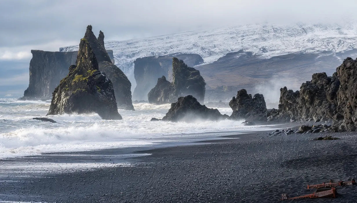
The Djúpalónssandur beach represents one of the most poignant cultural landscapes in West Iceland, serving as a tangible link to the nation's dangerous fishing history. The site solves a historical puzzle regarding how communities assessed labor strength before modern machinery. Four lifting stones, known as liftingarsteinar, remain scattered across the pebbles: the smallest weighs 23 kilograms (51 pounds), while the largest, Fulltingi, weighs 154 kilograms (340 pounds). Legend dictates that any man who could lift the heaviest stone was deemed fully capable of joining a fishing crew, a pragmatic solution to survival in harsh seas.
Beyond folklore, the location fulfills a somber memorial need. On March 13, 1948, the British trawler Epine ran aground during a storm, claiming 14 lives. The twisted steel wreckage visible today—boilers, winches, and hull fragments—was left intentionally as a warning against the ocean's unpredictability. In 2001, the area became part of Snæfellsjökull National Park, covering 170 square kilometers to protect the fragile ecosystem from vehicle damage. The beach composition consists of smooth black basalt pebbles, polished by centuries of wave action, distinct from the coarse sand found elsewhere. Walking these grounds, you traverse a space where geology and tragedy intersect. The site stands as a testament to resilience, reminding visitors that the sea provides sustenance but demands a heavy toll.
The Best Time to Experience Djúpalónssandur Beach
For safe hiking and optimal lighting, plan your visit between June 15 and August 20, when daytime temperatures range from 10–15°C (50–59°F) and daylight extends nearly 24 hours. The best photography conditions occur between 4:00–7:00 PM, when the sun angle highlights the texture of the black pebbles without creating harsh shadows on the wreckage. During these months, Road 574 is fully accessible for 4WD vehicles, and the 2.5-kilometer hiking trail remains dry and stable.
Shoulder season (May 1–June 14 and August 21–September 30) brings cooler temperatures of 5–10°C (41–50°F) and fewer visitors, but weather becomes unpredictable with occasional snow squalls even in late May. Winter visits (November–March) are strongly discouraged; temperatures drop to -5 to -10°C (14–23°F), daylight shrinks to 4–6 hours, and the trail becomes icy and hazardous. Additionally, Road 574 often closes due to snow accumulation, making access impossible without a super jeep.
Avoid visiting during storm warnings issued by the Icelandic Meteorological Office, as wind speeds can exceed 30 m/s (67 mph), making walking near the cliffs dangerous. The site is open 24 hours with no entrance fee, but the parking lot is unstaffed. Always verify road conditions at road.is and weather forecasts at vedur.is before departure, as the Djúpalónssandur beach access route can flood during rapid thaw events even in summer.
Approximate Budget for a 7-Day Trip (2026)
West Iceland offers moderate pricing compared to the south, though 4WD rental requirements increase transportation costs. These 2026 estimates assume a mid-range travel style, accounting for Iceland's projected 3.5% inflation rate and current exchange rates (1 USD = 0.92 EUR). Prices reflect the Snæfellsnes region, with accommodation based in Stykkishólmur or Hellnar.
- Accommodation: €150–€220 per night for guesthouses or hotels in Stykkishólmur (harbor view); budget hostels from €80; luxury hotels €300+
- Food: €70–€95 per day—breakfast €15 (often included), lunch €25 (seafood soup at Bjarnarhöfn Shark Museum), dinner €40–€55 (lamb or fish at local restaurants)
- Transportation: Rental car essential: €90–€120/day for 4WD vehicle (gravel protection recommended); fuel €2.20/liter (approximately €150 for week); Reykjavík to Djúpalónssandur round-trip: 260 km; Route 1 plus Route 54 and 574
- Attractions: Djúpalónssandur free; Snæfellsjökull National Park free; Shark Museum €12; Whale watching €90; Lava Centre €15
- Miscellaneous: Wool sweater €100–€150; thermal gear rental €35; travel insurance €55; parking fees €0
Total estimated cost for 7 days: €1,800–€2,300 per person (excluding international flights)
7 Essential Djúpalónssandur Beach Experiences
- Hike the Coastal Trail: This marked 2.5-kilometer path leads from the parking lot to the shoreline. Start at the gate (64°53.500'N, 23°53.800'W). The walk takes 45 minutes each way over uneven lava rock. Best visited mid-morning when wind is calm. Wear sturdy boots for ankle support. The view opens dramatically upon reaching the coast.
- Examine the Shipwreck Remnants: The rusted iron pieces of the Epine are scattered near the water's edge. Do not climb on the metal; it is sharp and unstable. Walk around the perimeter respectfully. The largest boiler lies 50 meters from the tide line. Best photographed late afternoon when rust contrasts with black stone.
- Test the Lifting Stones: Four stones lie near the center of the beach. Try lifting the smallest (23 kg) for a photo, but respect the largest. Do not attempt the 154 kg stone unless trained; injury risk is high. The stones are historical artifacts, not gym equipment. Best visited midday when other hikers can spot you.
- Photograph the Pebble Texture: The black basalt pebbles are smooth and photogenic. Get low to the ground for macro shots. Use a polarizing filter to reduce glare from wet stones. The composition requires a wide-angle lens (16–35mm). Expect wet feet; wear waterproof boots. Best light occurs between 4:00–7:00 PM.
- Visit the Information Boards: Located at the trailhead, these panels explain the 1948 wreck and park rules. Read them before hiking to understand the context. Open 24/7. No entry fee. Best visited before starting the hike. It provides crucial cultural context for the landscape.
- Watch the Tide Change: The wreckage becomes partially submerged at high tide. Check tide tables at the visitor center. Return to the beach 2 hours later to see the difference. The sound of waves moving pebbles is hypnotic. Best experienced without wind noise interfering. It grounds you in the natural landscape.
- Experience the Midnight Sun Glow: On June 21, the sun sets around 12:15 AM. Return to the beach around 11:00 PM to see the pebbles glow amber in perpetual twilight. Temperatures drop rapidly; wear thermal layers. The site is empty at this hour, offering profound solitude. The light on the water is surreal.
3 Hidden Gems Most Travelers Miss
- Saxhóll Crater Viewpoint: Located 15 kilometers east, this volcanic crater offers a view back toward the coast. Most tour buses skip it for the beach. Access via Route 574. The climb takes 10 minutes and offers 360-degree views of the peninsula. Open daylight hours; no entry fee. Best visited late evening when wind is calm. No facilities—bring water.
- Old Fishing Trail Remnants: Near the parking area, faint traces of the original path used by fishermen remain visible. Most visitors walk the new boardwalk. Look for the old stone cairns marking the route. Access is unrestricted during daylight hours. This spot offers tangible history of Iceland's infrastructure development. Best visited late afternoon when shadows highlight the ruts.
- Loðfílavík Cove: Drive 5 kilometers north to this secluded bay accessible via a rough track. It lacks the fame but offers raw power in a rugged setting. Access via unpaved road off Route 574 (4WD required). Open daylight hours; no entry fee. Most travelers miss this due to road conditions. Contact: snf.is for track status. Best visited midday.
Cultural & Practical Tips
- Respect the Wreckage: The ship remnants are protected historical artifacts. Do not remove pieces as souvenirs. Damage to cultural heritage is taken seriously. Fines for removing artifacts can reach €500. Stay on marked paths to preserve the fragile ecosystem.
- Weather Preparedness: West Iceland weather is volatile. Even in July, pack: windproof waterproof jacket, thermal base layers, sturdy hiking boots, hat and gloves. Check vedur.is for real-time forecasts. Wind speeds can exceed 25 m/s (56 mph), making exposed areas dangerous.
- Photography Etiquette: Tripods permitted but don't block pathways for other visitors. Drone use requires special permit from Umhverfisstofnun (Icelandic Environment Agency)—apply at ust.is at least 14 days in advance. Respect private property near farms; do not trespass for angles.
- Driving Safety: Route 574 is gravel and rough. Drive slowly to minimize dust for other travelers. 2WD vehicles risk damage; 4WD is recommended. Single-lane bridges are common; yield to vehicles already on the bridge. Speed limits are strictly enforced by automatic cameras.
- Local Phrases: Learn these Icelandic essentials: Takk (tahk) = Thank you; Góðan daginn (go-than die-in) = Good day; Falleg strönd (fal-leg strond) = Beautiful beach. Effort with language earns warm smiles from locals.
- Emergency Contacts: Dial 112 for all emergencies. Nearest hospital: Stykkishólmur Health Center (+354 438-1000) or Akranes Hospital for major issues. Cell coverage is spotty at the beach; download offline maps via Google Maps before arrival.
- Accessibility Note: The trail is not wheelchair accessible due to lava terrain. The parking area is gravel. Contact visitsnaefellsnes.is for detailed accessibility maps before traveling.
Conclusion: Travel with Reverence, Not Just Checklists
The Djúpalónssandur beach demands more than a quick photo stop and a hashtag—it asks for your patience, your respect, your willingness to stand quietly before a landscape that has witnessed tragedy and time. As you visit this site in 2026, remember that each footprint lands on ground sacred to both geological history and human memory. The wreckage isn't merely a scenic backdrop; it is a solemn reminder of the sea's power, written in rust and stone.
Responsible travel here means staying on paths, respecting artifacts, and leaving only footprints on the pebbles. It means understanding that the communities here are not just service providers but guardians of a fragile environment. When you purchase from local farms, hire West Icelandic guides, and follow road safety rules, you participate in an economy that values preservation over exploitation.
So linger past the guidebook's recommended 30 minutes. Sit on a sun-warmed rock and watch waves polish the black stone. Let the sound of the ocean remind you that some places aren't meant to be conquered or consumed—they're meant to be witnessed with humility, protected with intention, and carried in memory long after your tires have left the gravel road.