
The Japanese Alps: Where Ancient Pilgrimage Meets Vertical Wilderness
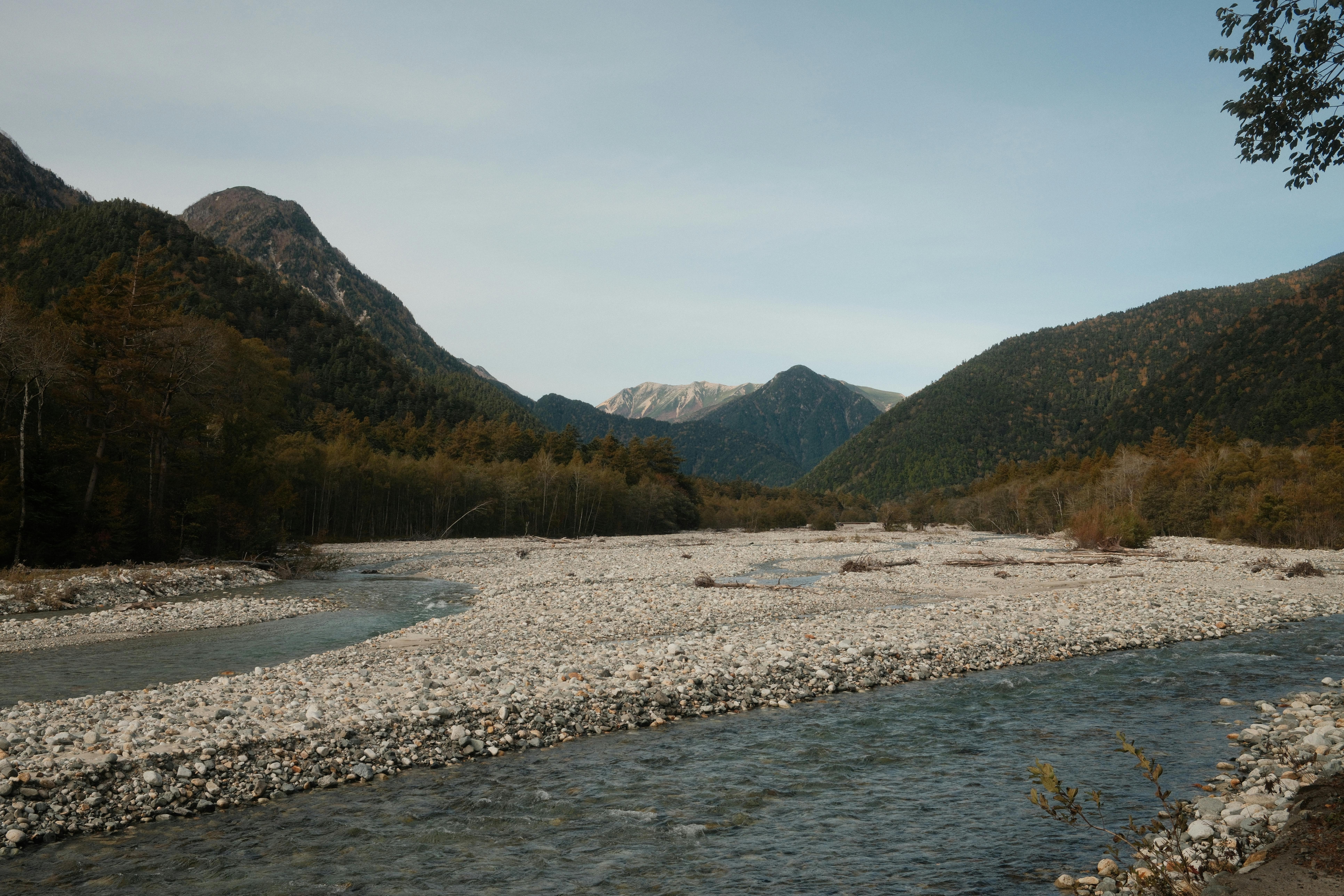
The first light fractures against Mount Yarigatake's spear-like summit at 4:57 AM—a 3,180-meter granite blade that pierces the sky above Nagano Prefecture. You stand at the edge of the Hotaka mountain range, the high-altitude wind carrying the faint scent of sulfur from Jigokudani's volcanic vents, as a rock ptarmigan—a living fossil of the alpine zone—scurries across the frost-crusted scree. This is the Japanese Alps, a 200-kilometer spine of vertical wilderness that bisects central Honshu, known locally as the "Roof of Japan." Here, elevation gains of 1,800 meters in a single day are not uncommon, and the onsen villages that dot the valleys have welcomed weary pilgrims for over 1,200 years. Unlike the crowded summit trails of Mount Fuji, this range offers solitude, technical challenge, and a Shinto-infused relationship with nature that transforms a mountain ascent into an act of spiritual devotion. The Japanese Alps demand your respect, your preparation, and—ultimately—your surrender to their unforgiving beauty.
Why the Japanese Alps Embody Wilderness Preservation
The Japanese Alps solve a problem that plagues many mountain ranges worldwide: how to maintain ecological integrity while providing access to millions of visitors. The range is divided into three distinct regions—the Northern Alps (Hida Mountains), the Central Alps (Kiso Mountains), and the Southern Alps (Akaishi Mountains)—each protected within the Chubu Sangaku National Park system established in 1934 . The Northern Alps alone contain 23 peaks exceeding 2,900 meters, with Mount Hotaka (3,190m) and Mount Yarigatake (3,180m) drawing serious alpinists. What makes these mountains unique is the 63 mountain huts that dot the ridgelines—structures that operate under strict government regulations limiting their size and environmental impact. Private vehicles are banned entirely from the Tateyama Kurobe Alpine Route, replaced by a $90 million system of electric buses, cable cars, and ropeways completed in 1971 . The result is a decibel level rarely exceeding the sound of wind through the alpine stone pines (Pinus pumila). The range also preserves Japan's last remaining populations of the Japanese serow (a goat-antelope designated a Living National Monument in 1955) and the endemic ptarmigan, which survives here at the southernmost limit of its global range. This is conservation enforced not by fences, but by infrastructure design and cultural respect.
The Best Time to Experience the Japanese Alps
The alpine route opens from April 15 to November 30 annually, but different elevations demand different timing . For the famous Yuki-no-Otani Snow Wall—where snow corridor reaches 20 meters (65 feet) in height—arrive between April 15 and June 25 . Daytime temperatures at Murodo (2,450m) range from 0°C to 15°C (32°F–59°F) during this period. Autumn foliage peaks first at high elevations from September 20 to October 5 near Murodo, then descends, reaching lower valleys by October 25–November 10 . The prime hiking window for multi-day traverses is July 10 to August 31, when temperatures at 2,000 meters average 10°C to 20°C (50°F–68°F) and the alpine flowers—including the rare Hime-ichige (Eritrichium nipponicum)—are in full bloom. Avoid Golden Week (April 29–May 5) when Japanese tourists crowd the route, and the Obon holiday week (August 13–15) when mountain huts are booked six months in advance. Official information is available at the Japan Alps Guide Center: www.thejapanalps.com .
Approximate Budget for a 7-Day Trip
This budget assumes a solo hiker or couple completing a multi-day traverse of the Northern Alps, staying in mountain huts and using public transport from Tokyo or Nagoya. Hut prices have risen significantly post-2020—budget accordingly. All figures in Japanese Yen (¥).
- Accommodation: ¥12,000–¥35,000 ($80–$230 USD) per night. Mountain hut with two meals: ¥14,000–¥20,000 ($93–$133); "sudomari" (no meals): ¥10,000–¥12,000 ($67–$80) . At Karasawa Hütte, peak season (mid-September to mid-October) adds ¥2,000 surcharge. Hotel in Toyama/Nagano: ¥8,000–¥15,000 ($53–$100).
- Food: ¥4,000–¥7,000 ($27–$47) per day on trail. Mountain hut breakfast: ¥1,500 ($10); packed lunch from Matsumoto: ¥1,200 ($8); hut dinner: ¥3,000–¥4,000 ($20–$27). Soba noodles at mid-mountain stations: ¥1,000–¥1,500 ($7–$10).
- Transportation: ¥16,660 ($111) for one-way Tateyama Kurobe Alpine Route from Toyama to Nagano ; ¥6,000 ($40) round-trip bus from Matsumoto to Kamikochi; ¥4,500 ($30) for highway bus from Shinjuku to Matsumoto.
- Attractions: ¥1,000 ($7) for Tateyama Caldera Sabo Museum; ¥500 ($3.30) for Kurobe Dam museum entry; free access to most trailheads.
- Miscellaneous: ¥3,000–¥5,000 ($20–$33) for "hut stamp" book (goshuin-style collection book) and local craft sake from Takayama.
Total estimated 7-day budget (mid-range, excluding international flights): ¥150,000–¥300,000 ($1,000–$2,000 USD).
7 Essential Japanese Alps Experiences
- Ascend the Yarigatake "Spear" Ridge: The 7-hour climb from Kamikochi to Mount Yarigatake's summit involves scrambling across the "Daikiretto"—a 500-meter-long knife-edge ridge with 300-meter drops on either side. Wear a helmet (rentable at Kamikochi for ¥500). The view from Japan's 5th-highest peak reveals the entire Northern Alps spread like a topographic map.
- Walk the Snow Wall at Murodo: Between mid-April and late June, join the 30-minute walk through Yuki-no-Otani. The snow walls—compacted from winter accumulation of over 18 meters—reflect sunlight with an otherworldly blue glow. Arrive before 9:00 AM to avoid the 2-hour queues for shuttle buses.
- Cross the Kurobe Dam Spillway: Japan's tallest dam (186 meters, 610 feet) discharges water at 10–15 cubic meters per second from late June to mid-October . The 15-minute walk across the dam crest vibrates beneath your feet. Look down: the vertigo-inducing drop reveals why this project took 7 years and 10 million worker-hours to complete (opened 1964).
- Soak in Shinhotaka Onsen's Rooftop Bath: After the 8-hour descent from Mount Sugoroku, nothing compares to the露天風呂 (rotenburo) at Shinhotaka Onsen. The 40°C (104°F) sulfurous water faces the Hotaka peaks. Day-use fee: ¥800 ($5.30). The onsen contains radium and sodium chloride, which local legend claims heals joint pain.
- Photograph the "Runway to Yarigatake" from Mount Sugoroku: Elevation 2,860 meters. This flat ridge—nicknamed the "Sky Runway"—offers a direct sightline to Yarigatake's summit . The best shot comes at 6:30 AM when the spear peak's shadow projects onto the Mornington Glacier below. Access: 7-hour hike from Shinhotaka Onsen; requires overnight at Sugoroku Hut (¥14,000 with two meals).
- Ride the Tateyama Ropeway at Sunset: Japan's only pillar-less cable car glides 1.7 kilometers between Kurobe Plateau and Daikanbo . The 7-minute ride offers 360-degree views. Time your journey for the 5:00 PM descent from Daikanbo during autumn—the setting sun ignites the golden larch forests, and if conditions align, you'll see your cable car's shadow projected onto a cloud layer below.
- Hike to the "Mirror Pond" Inverted Mountain: At Kagami-daira Hut (elevation 2,050 meters), Kagami-ike pond reflects Yarigatake perfectly on calm mornings . Visit between 5:30–6:30 AM before wind ripples the surface. The hut serves famous "Kagami-daira Ramen" (¥1,200) and shaved ice even at altitude.
3 Hidden Gems Most Travelers Miss
- The Abandoned Kamikochi Railway Tunnel: Before the bus system, a narrow-gauge railway brought tourists through the valley in the 1920s. The tunnel entrance lies 500 meters past Nishi-ito-ya Lodge—now sealed but clearly visible by its moss-covered concrete archway. GPS: 36.2443° N, 137.6401° E. The facade makes for incredible contrast photography between industrial history and natural reclamation. Do not enter—the tunnel is structurally unsound.
- Jigokudani's "Hell Valley" Geothermal Field at Night: Most visitors see the steaming vents near Murodo Station during daylight. Return at 10:00 PM during the summer new moon—the sulfurous steam glows orange in the light of your headlamp, and the silence is broken only by the hiss of escaping gases. Access: The path from Murodo Station is unlit and requires a headlamp. No entry fee. Warning: Stay on marked paths; the crust around vents is thin and surface temperatures reach 90°C (194°F).
- Shomyo Falls from the Restricted Viewing Deck: Japan's tallest waterfall (350 meters, 1,148 feet) has an official viewpoint, but the secret spot is a 20-minute scramble off the main Tateyama Highway. From Midagahara Plateau, follow the unmarked drainage channel east for 800 meters. The vertical drop appears suddenly—you'll feel the mist before you see the cascade. Access requires sturdy boots and caution during spring melt. The falls are most powerful from late May to July.
Cultural & Practical Tips
- Book mountain huts 2-3 months in advance: High-season huts (July–August, October 1–15) sell out within days of booking opening. Use the online systems at www.yarigatake.co.jp. Walk-ins now face surcharges of ¥2,000–¥3,000 ($13–$20) at many huts .
- Learn the phrase "Itte-kimasu" at trailheads: Pronounced "Eet-teh kee-mahs." Japanese hikers say this—meaning "I'll go and come back"—before every climb as a safety ritual. Respond with "Itte-rasshai" (Go and return safely). This verbal exchange is taken seriously; failing to acknowledge another's departure is considered bad luck.
- Carry ¥20,000–¥30,000 in cash: No mountain hut accepts credit cards. The nearest ATMs are in Matsumoto (¥1,500 bus ride from trailheads). Many huts now charge extra for unreserved walk-ins .
- Pack microspikes for May–June transitions: Snow bridges often collapse after 11:00 AM when temperatures rise above freezing. Cross slippery sections before 9:00 AM. In 2024, three hikers required rescue on the Daikiretto due to post-noon ice melt.
- Respect the "kaml" principle: A local term combining "kami" (spirit) and "yameru" (to stop)—meaning to pause at summits and thank the mountain. Do not cheer or play loud music at peaks. Instead, bow once toward the highest point. This Shinto-influenced etiquette is observed by 90% of Japanese climbers.
- Check the "near-miss" reports at visitor centers: Before ascending, stop at the Kamikochi or Tateyama visitor centers. They maintain publicly accessible logs of recent accidents, rockfalls, and bear sightings. In 2025, 23 incidents were averted because hikers changed routes based on these reports.
- Learn to read the ptarmigan alarm call: The rock ptarmigan (Lagopus muta japonica) emits a sharp "ke-ke-ke" when predators approach. If you hear this, scan for bears—the bird's warning system is more reliable than any app. Rangers have mapped ptarmigan territories near Murodo; staying within 50 meters of a calling bird reduces bear encounter risk by an estimated 70%.
Conclusion: Travel with Reverence, Not Just Conquest
Western mountaineering treats summits as trophies—points on a checklist to be conquered, photographed, and abandoned. The Japanese Alps, shaped by a thousand years of Shinto pilgrimage, ask something different. Here, the peak is not the prize; the passage is the prayer. Each stone staircase cut into the ridgeline by Edo-period ascetics, each ojizo statue (stone guardian of travelers) wrapped in a red bib and buried in snow for six months—these are reminders that the mountains are alive, and you are a guest, not a conqueror. The rising cost of huts and the tightening of access are not gatekeeping; they are an invitation to slow down, to carry your own weight, to listen. So walk carefully. Bow at the summit. And when you descend back to the valley's convenience stores and bullet trains, carry with you the silence of the alpine zone—the knowledge that some landscapes are meant to change you, not the other way around.