
High Coast Bridge: Where Engineering Ambition Meets Arctic Waterways
The morning fog lifts at 8:30 AM in early October, revealing twin concrete pylons that rise 180 meters (591 feet) above the Ångerman River—their surfaces catching the first golden light like monoliths of pale stone. You stand at Hornöberget's viewpoint, 2 kilometers north of the bridge, and watch as the 1,867-meter suspension span emerges from the mist: a ribbon of steel and concrete that seems to float between the municipalities of Härnösand and Kramfors. The High Coast Bridge—Högakustenbron to locals—represents one of Scandinavia's most ambitious infrastructure projects, completed in 1997 after four years of construction that consumed one million working hours, 40,000 cubic meters of concrete, and 14,000 tonnes of steel . Before its existence, travelers between Stockholm and Luleå faced a 40-kilometer detour inland; now, the E4 highway crosses this waterway in 90 seconds. Yet the bridge offers more than efficiency—it provides a portal into the High Coast UNESCO World Heritage Site, where post-glacial land uplift continues to reshape the coastline at a rate unmatched anywhere on Earth.
Why High Coast Bridge Embodies Geological Resilience
The High Coast Bridge solves a fundamental problem of northern Swedish geography: how to cross the Ångerman River's mouth without impeding maritime traffic or requiring impossible engineering feats. The river's depth reaches 90 meters—far too deep for conventional bridge supports—while the waterway must remain navigable for cargo vessels requiring 40 meters of clearance . The solution: a suspension bridge with 1,210 meters between its towers, making it the third longest in Scandinavia and fourth longest in Europe at its completion .
The construction demanded innovation in harsh conditions. Engineers from COWI AS and Haug og Blom-Bakke A/S designed pylons with hollow cross-sections and inward-sloping legs, founded directly on solid rock . The 48 bridge deck modules—each 40 meters long and 21 meters wide—were manufactured in Finland and lifted into place by floating crane, with wind tunnel testing ensuring stability against Arctic gales . The pylons withstand collision from 50,000-ton vessels at 16 knots, while 12-meter glass pyramids crown each tower—aesthetic flourishes that catch the low Arctic sun . When King Carl XVI Gustaf inaugurated the bridge on December 1, 1997, it became Sweden's tallest structure, surpassed only by the Öresund Bridge three years later .
The Best Time to Experience High Coast Bridge
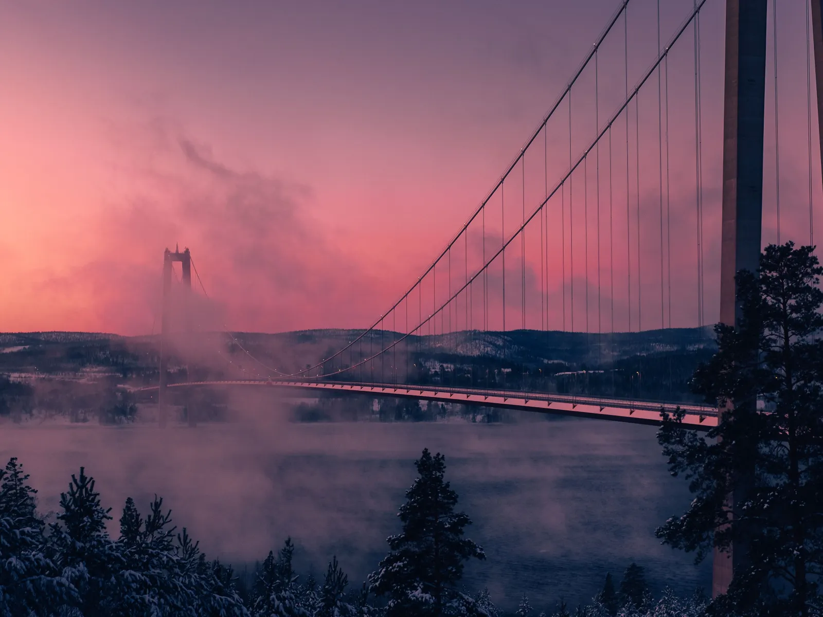
For optimal photography and hiking conditions, visit between September 1–September 20, when autumn colors peak across the High Coast's birch and pine forests, temperatures range from 10°C to 18°C (50°F–64°F), and daylight extends 12–14 hours . During this window, the bridge emerges from morning mist at sunrise (approximately 6:30 AM), creating ethereal photographic opportunities as the pink-gold light illuminates the suspension cables against purple skies.
Summer visitors (June 20–August 15) enjoy temperatures of 15°C to 25°C (59°F–77°F) with nearly 22 hours of daylight during the midnight sun period, though July brings peak crowds to nearby Skuleskogen National Park and unpredictable rain . Winter offers dramatic snow-covered landscapes and possible aurora viewing from November 15–February 28, with temperatures between -10°C and -20°C (14°F to -4°F), though services are limited .
Avoid July 1–August 10, when Swedish holidaymakers flood the region, parking lots fill by 11:00 AM, and accommodation prices surge 30–40%. Late March through early May brings muddy trails and closed facilities between winter and summer operations .
For trail maps, accommodation booking, and seasonal activity information, visit the official tourism website: hogakusten.com
Approximate Budget for a 7-Day Trip
The High Coast region offers excellent value for Scandinavian standards, with accommodation and dining costs significantly lower than Stockholm or Gothenburg. Budget travelers can experience the bridge and surrounding UNESCO landscape without excessive expense.
- Accommodation: €65–€110 per night for mid-range hotels (Hotell Höga Kusten at the bridge's north end, Björkuddens Hotel on the south bank); €45–€75 for guesthouses and B&Bs in Härnösand or Kramfors; €25–€35 for camping at Snibbens Camping adjacent to the bridge .
- Food: €55 per day—breakfast €12 (hotel buffet or café pastry with coffee), lunch €18 (smörgåsbord at Wästerlund pastry shop near Sandö Bridge or moose meatballs with lingonberry), dinner €25 (locally caught whitefish or the infamous surströmming—fermented herring—at Ulvö Hotell during August season).
- Transportation: Train from Stockholm to Härnösand: €45–€65 (SJ or Norrtåg). Rental car: €50–€70 daily. Bus #100 between Härnösand and Kramfors: €8 one-way. The bridge itself carries no toll.
- Attractions: High Coast Trail hiking: free; Skuleskogen National Park entrance: free; Via Ferrata climbing at Skuleberget: €45; kayak rental at Björkudden to paddle under the bridge: €35–€50 daily; High Coast Whisky distillery tour: €25.
- Miscellaneous: Local cloudberry jam at Härnösand market: €8; handcrafted wooden utensils: €15–€30; Hernö Gin from Dala distillery: €35–€45.
Total for 7 days: €750–€1,200 per person (mid-range), excluding international flights.
6 Essential High Coast Bridge Experiences
- Photograph Sunrise from Hornöberget: Arrive at the viewpoint by 6:00 AM in autumn to capture the bridge emerging from river mist as the sun crests the eastern hills. The 180-meter pylons catch alpenglow while the suspension cables create geometric patterns against the sky. Bring a telephoto lens to compress the towers against the water.
- Walk the Bridge Pedestrian Path: Park at Snibbens Camping and access the northern approach, walking 1.5 kilometers along the designated pedestrian route. The experience of standing 40 meters above the Ångerman River—watching vessels pass beneath while traffic rumbles across the deck—provides visceral understanding of the engineering scale. The walk takes 45 minutes round-trip.
- Kayak Beneath the Span: Rent kayaks from Björkuddens Hotel & Restaurant on the south bank and paddle the 2-kilometer approach to the bridge. From water level, the 1,210-meter main span creates a cathedral-like arch overhead, with the glass pyramid crowns gleaming 180 meters above. The paddle takes 90 minutes and offers perspectives impossible from land.
- Cycle the Broarna Runt Route: Complete the classic "Tour Around the Bridges" circuit—35 kilometers connecting the High Coast Bridge with the historic Sandö Bridge (built 1943). The route follows the Ångerman River's north bank, passing Wästerlund pastry shop and the Ådalen 1931 memorial. Allow 3–4 hours with stops .
- Visit the Glass Pyramids at Close Range: Drive to the bridge's south abutment near Veda village and walk to the pylon base. The 12-meter glass crowns—visible for kilometers—reveal themselves as intricate steel frameworks with prismatic glass panels that shift color with the sun's angle. The pylons' concrete surfaces display the texture of their slip-form construction.
- Experience the Bridge from the High Coast Trail: Hike Section 1 of the 140-kilometer Höga Kustenleden, which begins at Hornöberget, passes beneath the bridge, and continues along the coastline. The 11-kilometer stage to Lövvik offers multiple bridge viewpoints from varying elevations, revealing how the structure integrates with the UNESCO landscape .
3 Hidden Gems Most Travelers Miss
- The Sandö Bridge Memorial: Located 8 kilometers west of the High Coast Bridge, this older concrete arch bridge (1943) features a memorial to the 1931 Ådalen shootings—where Swedish military fired on striking sawmill workers. Most visitors focus on the modern suspension bridge and miss this powerful site of Swedish labor history. Access via the Broarna Runt cycling route; the memorial plaque faces the river on the bridge's north side.
- The Original Ferry Landing at Veda: Before the bridge existed, the Veda-Utansjö ferry connected the riverbanks. Walk 500 meters west from the bridge's south abutment to find the old ferry ramp—now a quiet fishing spot with weathered wooden pilings and unobstructed views of the bridge's full span. Local anglers gather here at dawn; bring coffee and watch the sunrise in solitude.
- The Pylon Interior Staircase: While not open to regular tourists, engineers and architecture students can arrange access to the north pylon's maintenance staircase through the Swedish Transport Administration (Trafikverket) by contacting their Härnösand office at +46 (0)771-921 921 at least two weeks in advance. The climb reveals the hollow concrete structure's cathedral-like interior and offers views from inspection platforms at 60-meter and 120-meter levels.
Cultural & Practical Tips
- Respect the right of public access: Swedish allemansrätten allows hiking and camping on uncultivated land, but keep 70 meters from private residences and never pitch tents on agricultural fields. The bridge viewpoint at Hornöberget is public land.
- Learn essential Swedish: Hej (hey) for hello, Tack (tahk) for thank you, Ursäkta (oor-sehk-tah) for excuse me. English is widely spoken, but attempting Swedish earns warm appreciation in this rural region.
- Dress for rapid weather changes: The High Coast's maritime climate brings sudden shifts. Even summer mornings can drop to 8°C (46°F). Pack windproof layers and waterproof footwear for trail hiking.
- Photography guidelines: Drones are prohibited near the bridge without aviation authority permission due to E4 highway traffic. The best light occurs 30 minutes after sunrise and 45 minutes before sunset; the glass pyramids glow amber during golden hour.
- Understand the surströmming season: If visiting in August, respect the tradition of fermented herring consumption—eaten outdoors with potatoes, flatbread, and onions. The smell is notorious; never open cans indoors. The season peaks on the third Thursday of August .
- Plan for limited winter services: From November through March, many restaurants and accommodations close. Confirm opening hours in advance; Hotell Höga Kusten remains open year-round.
Conclusion: Travel with Perspective, Not Just Passage
The High Coast Bridge exists because humans refused to accept geographical constraints—because engineers looked at a 90-meter-deep river and saw possibility rather than obstacle. When you stand at Hornöberget's viewpoint, watching the sun ignite those glass pyramids 180 meters above the water, you witness the intersection of geological time and human ambition. The land beneath your feet continues rising—8 millimeters annually—pushed upward by ancient ice's retreat, while the bridge stands fixed, a statement of permanence against impermanence.
Approach this structure not merely as infrastructure but as a lens through which to understand the High Coast itself. The bridge connects not just two municipalities but two ways of seeing: the utilitarian demand for efficient travel and the romantic need for sublime experience. As you walk beneath its span or paddle beneath its cables, remember that the best journeys require both—practical passage and poetic pause. Travel here to cross the river, certainly, but also to understand what it means to build gracefully within landscapes that predate human memory by ten millennia.