
Kungsleden Hiking Trail: Where Arctic Wilderness Meets Ancient Sami Heritage
The air carries the crisp scent of crushed juniper, damp moss, and distant woodsmoke as you step onto the trail—each bootfall soft against the spongy tundra carpet. This is Kungsleden, Sweden's legendary King's Trail, stretching 440 kilometers (273 miles) from Abisko in the Arctic north to Hemavan in the south, a ribbon of red T-shaped cairns guiding travelers through one of Europe's last great wildernesses. The midnight sun hovers just above the horizon at 11:00 PM, casting golden light across birch forests, alpine meadows, and glacial valleys that have remained largely unchanged for millennia. You hear only the whisper of wind through dwarf willow, the distant call of a golden plover, and the rhythmic crunch of your own footsteps on gravel. This trail matters because it preserves not just a path, but a philosophy: that humanity can move through wild places with respect, leaving nothing but footprints and carrying away only understanding. Here, beneath the vast Arctic sky, you walk not to conquer distance, but to reconnect with a rhythm older than civilization itself.
Why Kungsleden Hiking Trail Embodies Arctic Wilderness Trekking
Kungsleden hiking trail represents one of Scandinavia's most ambitious conservation and recreation achievements, conceived in the early 1900s by the Swedish Tourist Association (STF) to provide safe, sustainable access to Lapland's remote wilderness. The trail solved a critical need: creating a marked, maintained route through terrain where navigation is challenging, weather unpredictable, and distances vast—enabling hikers to experience Arctic beauty without compromising the ecosystem. Today, the trail features over 20 mountain stations spaced 15–25 kilometers (9–15 miles) apart, each offering dormitory accommodation, meals, and emergency support, forming a unique infrastructure that balances accessibility with preservation.
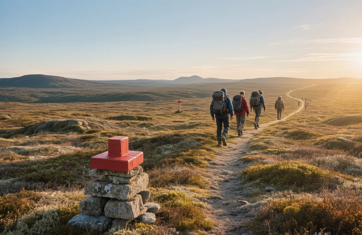
Engineering the Kungsleden hiking trail required innovative solutions for Arctic conditions: boardwalks protect fragile tundra in wet sections, while red T-shaped cairns—visible from 200 meters (656 feet) away—provide reliable navigation even in fog or snow. The trail's elevation ranges from 200 meters (656 feet) in valley bottoms to 1,200 meters (3,937 feet) at high passes, creating diverse habitats within a single route. Maintenance crews rebuild eroded sections annually using local materials, ensuring the path remains sustainable without heavy machinery. This thoughtful design allows over 10,000 hikers annually to experience the Arctic while minimizing ecological impact—a model for responsible wilderness tourism worldwide.
Beyond logistics, the trail fulfills a profound cultural function: it traverses traditional Sami reindeer herding lands, offering visitors opportunities to learn about indigenous stewardship of the Arctic. The STF collaborates with Sami communities to ensure trail routing respects migration corridors and sacred sites. This partnership makes Kungsleden hiking trail more than a recreational path; it is a living dialogue between modern outdoor culture and ancient land wisdom, inviting hikers to walk lightly, learn deeply, and leave the wilderness as they found it.
The Best Time to Experience Kungsleden Hiking Trail
For optimal hiking conditions on the Kungsleden hiking trail, target July 1–August 25, when snow has melted from high passes and temperatures average 10–18°C (50–64°F) during the day, dropping to 3–8°C (37–46°F) at night. The midnight sun in early July provides nearly 24 hours of daylight, extending safe hiking windows and reducing navigation challenges. For the northern section (Abisko to Nikkaluokta), start daily hikes between 7:00–9:00 AM to avoid afternoon cloud buildup and potential thunderstorms.
For autumn colors and fewer crowds, visit September 1–20, when temperatures range from 5–12°C (41–54°F) and birch forests turn brilliant gold. However, daylight shrinks to 12 hours, and early snow is possible above 900 meters (2,953 feet). Avoid hiking during late May–June and late September–October, when freeze-thaw cycles create unstable terrain, swollen rivers complicate crossings, and limited daylight increases risk. Also skip periods of high wind (over 12 m/s/27 mph), which make exposed ridges dangerous. For current trail conditions, weather forecasts, and mountain station availability, verify at www.swedishlapland.com before your expedition.
Approximate Budget for a 7-Day Trip
Traveling the Kungsleden hiking trail involves Swedish pricing standards, reflecting high-quality infrastructure and remote logistics. This budget assumes a 7-day section hike during peak summer season, balancing authentic wilderness experience with mid-range comfort. Prices reflect current rates and assume solo travel (costs decrease 25–35% per person for couples sharing accommodation).
- Accommodation: €85–€160 per night. Budget: STF mountain station dorm bed (€85/night). Mid-range: Private cabin at station (€120/night). Higher-end: Guided expedition package with meals (€160/night). Book 3–4 months ahead for July.
- Food: €35–€65 per day. Breakfast: €8–12 (station included or café with coffee, smörgås open sandwich). Lunch: €12–18 (packed trail meal: cheese, crispbread, dried fruit, chocolate). Dinner: €20–30 (hearty stew or salmon at station restaurant). Self-catering reduces costs by 40%.
- Transportation: Stockholm to Kiruna: €90–130 one-way via SJ Night Train (12 hours). Kiruna to Abisko (trailhead): €25 by shuttle bus (110 km/68 miles). Local bus between trail sections: €3.50 per ride. Car rental (4WD): €70/day plus fuel (€2.00/liter).
- Attractions: Kungsleden trail access: Free. Mountain station entry: Free (accommodation separate). Sami cultural experience: €40. Guided glacier walk: €35. Rescue insurance (recommended): €25. Boat transfer across lakes: €15.
- Miscellaneous: Trekking pole rental: €10/day. Sami craft souvenir: €30–70. Travel insurance (wilderness coverage): €55 for week. SIM card/ €18.
Total 7-day budget: €900–€1,400 (excluding international flights)
7 Essential Kungsleden Hiking Trail Experiences
- Hike the Abisko to Nikkaluokta Section: Begin at 8:00 AM from Abisko Turiststation, following red T-cairns through birch forest to alpine tundra. This 80-kilometer (50-mile) section takes 5–7 days, gaining and losing 2,000 meters (6,562 feet) of elevation. Stay at STF stations like Alesjaure and Tjäktjapass, where you can rest, refuel, and meet fellow hikers. The highlight: crossing Tjäktjapass at 1,150 meters (3,773 feet) for panoramic views of the Tarfala Valley and Kebnekaise massif. Start early to avoid afternoon clouds; carry rain gear regardless of forecast.
- Experience Midnight Sun Hiking: In late June, start your daily hike at 10:00 PM to walk beneath the eternal twilight. The light is soft and directional, casting long shadows that accentuate the tundra's textures. Temperatures remain mild at 12°C (54°F), and mosquitoes are less active. Use a headlamp only for river crossings; otherwise, natural light suffices. This unique experience transforms ordinary hiking into something magical—walking while the world sleeps, with only the wind and your footsteps for company.
- Stay at a Mountain Station: Book a dorm bed at STF Alesjaure (elevation 700 meters/2,297 feet) for an authentic wilderness lodge experience. Arrive by 4:00 PM to secure a bunk, then enjoy a communal dinner of reindeer stew or Arctic char. The station features a sauna, drying room for wet gear, and a library of Arctic literature. Evening conversations with hikers from around the world create unexpected connections. Wake at 6:00 AM for breakfast before continuing your trek. This infrastructure makes multi-day hiking accessible without carrying heavy camping gear.
- Cross a Glacial River: Learn safe river-crossing techniques at the guided session offered at major stations (10:00 AM, Tuesday and Thursday). Instructors demonstrate how to unbuckle backpack straps, use trekking poles for stability, and choose the safest crossing point. Practice on a shallow stream before attempting larger rivers like the Ladtjojåkka. The skill builds confidence for independent travel and deepens respect for Arctic hydrology. Never cross alone; always assess depth and current speed first.
- Observe Reindeer Migration: In July, watch for Sami herders guiding reindeer across the trail near Vistasravine. Maintain a respectful distance of 50 meters (164 feet); never approach or photograph without permission. The sight of hundreds of reindeer moving across the tundra—accompanied by herders on foot or bicycle—offers a glimpse into a way of life unchanged for centuries. This encounter reminds hikers that the wilderness is not empty, but stewarded by people with deep cultural ties to the land.
- Photograph the Red Cairns: Position yourself at trail junctions at 7:00 AM when morning light illuminates the iconic red T-shaped markers against green tundra or white snow. Use a wide-angle lens to capture the cairns leading into the distance, creating leading lines that draw the eye through the composition. Include a hiker for scale; the vastness of the landscape is best understood with human reference. Avoid midday sun, which flattens textures; golden hour (10:00 PM–2:00 AM in June) provides the most dramatic light.
- Wild Camp Under the Stars: For experienced hikers, obtain a wilderness permit (free, register at any station) and camp at designated sites along the trail. Pitch your tent at 9:00 PM in a protected spot away from water sources, cook a simple meal on a portable stove, then watch the sky transition from twilight to starlight without light pollution. Wake at 5:00 AM for sunrise photography. This immersive experience demands self-sufficiency but rewards with profound solitude. Follow Leave No Trace principles strictly; the Arctic ecosystem recovers slowly from disturbance.
3 Hidden Gems Most Travelers Miss
- Sitojaure's Hidden Waterfall: Located 3 kilometers (2 miles) east of the Sitojaure mountain station, this 15-meter (49-foot) cascade plunges into a turquoise pool surrounded by alpine flowers. Access via an unmarked path: from the station, follow the eastern shore of Lake Sitojaure for 20 minutes until you spot the waterfall's mist. Visit at 11:00 AM when sunlight illuminates the spray, creating rainbows. Why overlooked: It lacks signage and requires slight off-trail navigation. Insider tip: Bring a polarizing filter to enhance water clarity in photographs; the pool is cold but safe for a quick dip if weather permits.
- Tjäktjapass Sunrise Platform: At the summit of Tjäktjapass (1,150 meters/3,773 feet), a flat rock outcrop 100 meters north of the main trail offers unobstructed 360-degree views. Arrive at 4:00 AM in July to witness sunrise over the Tarfala Valley while most hikers sleep. The platform is unmarked; look for the large cairn with a small wooden bench. Why overlooked: Exhausted hikers often descend immediately after crossing the pass. Insider tip: Bring a thermos of coffee and a warm layer; wind chill at elevation can drop temperatures 10°C (18°F) below valley readings. This quiet moment atop Sweden's most famous pass is unforgettable.
- Vistasravine's Sami Story Stones: Near the Vistasravine mountain station, a cluster of small, flat stones arranged in a circle marks a traditional Sami storytelling site. No signage identifies this spot; ask station staff for directions or look for the birch tree with a carved reindeer symbol. Visit at 5:00 PM when afternoon light softens the landscape. Why overlooked: Cultural sites are subtle and require cultural awareness to recognize. Insider tip: Sit quietly for 10 minutes; the wind through the stones creates a gentle chiming sound that Sami tradition associates with ancestral voices. Do not move stones or leave offerings unless you understand the tradition.
Cultural & Practical Tips
- Respect Sami land rights: Kungsleden hiking trail traverses traditional Sami reindeer herding areas. Stay on marked trails to avoid disturbing grazing grounds or sacred sites. Never approach reindeer closer than 50 meters (164 feet); they are semi-domesticated working animals, not wildlife. If you encounter a sieidi (sacred stone), observe silently and do not touch. The Sami have stewarded this land for over 5,000 years; their cultural sovereignty deserves reverence.
- Learn essential Swedish phrases: "Tack" (tahk = Thank you), "Hej" (hay = Hello), "Led" (layd = Trail). Pronunciation matters less than effort—staff appreciate attempts at their language.
- Photography guidelines: Use a polarizing filter to reduce glare from water and snow. For landscape shots, shoot at f/11 for depth of field; include human figures for scale. Drones require permit from transportstyrelsen.se; apply 2 weeks ahead. Avoid photographing Sami individuals without explicit permission. The best light occurs during golden hour (10:00 PM–2:00 AM in June).
- Safety considerations: Always carry emergency supplies: headlamp, fire starter, emergency blanket, and high-energy food. Weather changes rapidly; check forecasts at smhi.se before every outing. Inform mountain stations of your route and expected return. Hypothermia is a risk even in summer; change out of wet clothes immediately. River crossings are the most common hazard; never cross alone.
- Equipment essentials: Sturdy hiking boots with ankle support are non-negotiable. Pack layers: moisture-wicking base, insulating mid-layer, windproof shell. Bring trekking poles for river crossings and scree sections. Sunglasses and sunscreen are essential; UV radiation intensifies at altitude. A 40-liter pack with rain cover completes your kit. Rent gear at STF stations if needed.
- Leave No Trace: Pack out all trash, including biodegradable items. Use designated toilets at stations; bury human waste 15–20 centimeters (6–8 inches) deep and 70 meters (230 feet) from water sources if camping wild. Do not pick alpine flowers; they grow slowly in harsh conditions. Respect wildlife by observing from a distance. The Arctic ecosystem recovers slowly from disturbance.
- Connectivity: Mobile coverage is limited to mountain stations and lower valleys. Download offline maps before arrival. Satellite communicators (Garmin inReach) recommended for remote sections. WiFi available at stations but unreliable during peak hours. Inform family of limited communication before departure.
Conclusion: Travel with Reverence, Not Just Endurance
Kungsleden hiking trail invites you to slow down—to measure your journey not by kilometers covered, but by understanding deepened. This is not a path to conquer; it is a wilderness that demands humility, asking you to feel the weight of ancient landscapes, to witness the delicate balance of Arctic ecosystems, to recognize that you are a guest in a realm shaped by forces far older than humanity. When you travel here with reverence, you honor the Sami people whose heritage intertwines with these slopes, support conservation efforts that protect fragile tundra, and contribute to a tourism model that values preservation over exploitation. As you leave Kungsleden hiking trail, carry forward the understanding that true adventure lies not in completing the route, but in allowing the wilderness to reshape your perspective. The cairns will remain long after you depart, marking the way for the next traveler willing to walk lightly, learn deeply, and leave the Arctic as they found it—wild, whole, and worthy of protection.